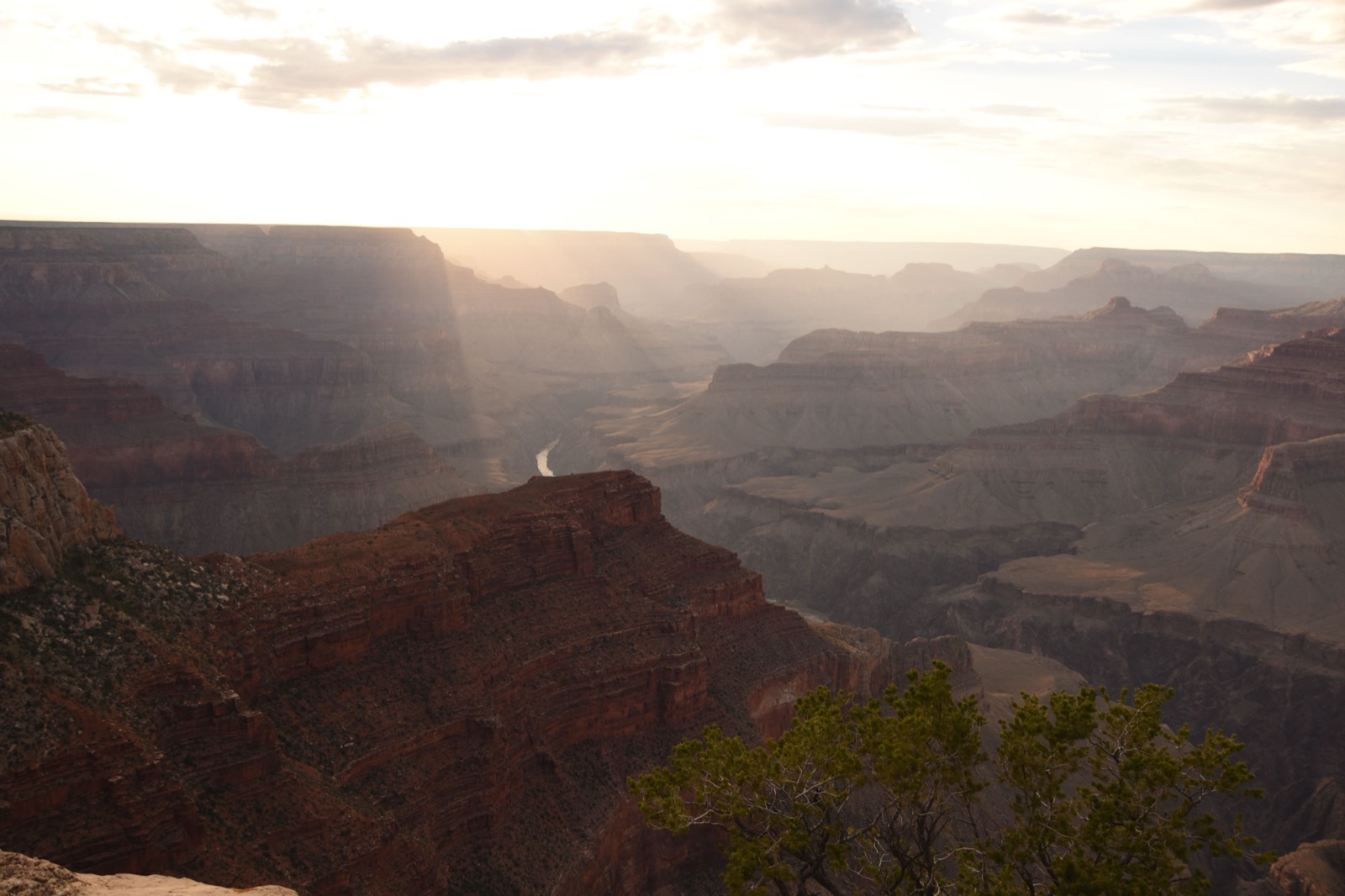
Almost everyone who drives this corridor for the first time tries to do it as a round-trip day from Phoenix, and it is a mistake. The math is unforgiving: about 230 miles each way, three and a half to four hours of driving in each direction, which is seven to eight hours behind the wheel to spend, realistically, two to four hours standing at the rim before you have to turn around and drive back in the dark. You will have seen the Grand Canyon at flat midday light, fought the worst of the entrance queue, and reduced one of the world's great landscapes to a photo stop. The drive is easy; the day trip is the trap. Overnight in Tusayan, Williams, or Flagstaff and the same trip becomes a sunrise or a sunset at the rim instead of a rushed lunch-hour glimpse — which is the entire difference between having driven to the Grand Canyon and having actually been there.
As a piece of driving, Phoenix to the South Rim is genuinely simple: Interstate 17 North out of the Valley to Flagstaff, Interstate 40 West to Williams, and State Route 64 North to Grand Canyon Village. Three roads, two turns, about 230 miles. What makes it worth treating as a trip rather than a transfer is the 6,000 feet of elevation you gain along the way — from Sonoran desert at the Phoenix floor to ponderosa-pine high country at the rim — and the decisions that elevation forces: when to leave, where to sleep, which of two scenic finishes to take, and how to dodge the midday crowd that turns the last hour into a parking war.
This guide sequences the whole thing in real geographic order — Phoenix, the Verde Valley climb around Camp Verde, Flagstaff, Williams on old Route 66, Tusayan at the gate, and Mather Point on the rim — and is honest about the two route choices, the $35 vehicle pass (plus a $100-per-person nonresident surcharge for non-U.S. visitors), the entrance-queue windows, and the fuel and altitude details that the glossier guides leave out. There are no affiliate booking links on this page; it is the route, not a sales pitch.
One framing decision up front: this is the South Rim, the developed, year-round, easiest-to-reach rim and the one 90 percent of first-time visitors mean when they say "the Grand Canyon." The North Rim is a different, much longer drive and is closed in winter; it is not this trip. Everything below assumes the South Rim and Grand Canyon Village.
Methodology
How this route was built and what the numbers are based on, so you can judge whether our calls match your trip:
- The route: the waypoints follow the actual standard corridor in real geographic order — Phoenix, the Verde Valley around Camp Verde, Flagstaff, Williams, Tusayan, and the rim at Mather Point — via I-17 North, I-40 West, and SR-64 North. This is the road the overwhelming majority of South Rim visitors drive; we did not invent a scenic detour, though we name the US-180 alternate from Flagstaff where it genuinely competes.
- Distances and times: the ~230 miles and ~3.5 to 4 hours are approximate driving figures for the Phoenix-to-South-Rim leg, given as honest round numbers rather than false-precise readings. We deliberately quote a range, not a single figure, because the climb from ~1,100 feet to ~7,000 feet, a fuel stop, and seasonal traffic all move the total. Treat four hours as the planning number.
- The day-trip warning is the load-bearing call: the round-trip math — roughly 460 miles and seven to eight hours of driving for a few hours at the rim — is the single most important fact on the page, and every recommendation below is weighted toward an overnight in Tusayan, Williams, or Flagstaff rather than an out-and-back.
- What we name vs. what we don't: we name confirmed, durable features — the $35 seven-day private-vehicle pass (plus the $100-per-person nonresident surcharge for non-U.S. visitors, effective January 1, 2026), the south entrance station, Mather and Yavapai Points, the Hermit Road shuttle, the Grand Canyon Railway from Williams. For lodging and operators whose hours and prices shift, we point to the category (overnight towns; the seasonal Tusayan shuttle) rather than vouch for a specific business's current details.
- Seasonality and altitude: the winter snow caution on US-180 and the Peaks, the summer entrance-queue windows, and the 25-to-30-degree temperature drop at the rim come from the corridor's documented climate and elevation. The rim sits at roughly 7,000 feet, so it is a different climate from Phoenix in every season.
- Refresh cycle: entrance fees, shuttle service, and queue guidance re-checked seasonally; route and overnight logic re-verified before each peak summer season. Last verified: 2026-06-13.
At a Glance: The South Rim Route, Stop by Stop
| Stop | Place | ~Drive from Phoenix | Time There | Why This Stop |
|---|---|---|---|---|
| The Drive — I-17 N → I-40 W → SR-64 N, ~230 mi / ~3.5–4 hrs | ||||
| 1 | Phoenix departure (the Valley) | 0 mi — start | — | Leave early to beat the 9am entrance queue, or late for sunset + an overnight. Pick up I-17 North out of the metro with a decent tank. |
| 2 | Camp Verde / Verde Valley | ~90 mi / ~1.5 hrs | 20–30 min | The desert-to-high-country transition on I-17. Natural mid-drive fuel-food-restroom break before the climb to Flagstaff. |
| 3 | Flagstaff (I-17 / I-40 junction) | ~145 mi / ~2.25 hrs | Pass-through or overnight | The ~7,000 ft mountain-town hinge. Largest town near the rim, the US-180 scenic-alternate launch, and a basecamp option. |
| 4 | Williams — Gateway to the Grand Canyon | ~175 mi / ~2.75 hrs | Overnight or fuel stop | The SR-64 turnoff and the practical overnight. Grand Canyon Railway depot — the car-free way up. Last reliable fuel before the rim. |
| The Rim — Tusayan, the Gate & the South Rim | ||||
| 5 | Tusayan (south entrance gateway) | ~225 mi / ~3.5 hrs | Overnight option | Last town before the park, minutes from the rim. Closest lodging for sunrise; seasonal shuttle skips the in-park parking scramble. |
| 6 | Grand Canyon South Rim — Mather Point | ~230 mi / ~3.5–4 hrs | Half day+ | Arrival. First look by the visitor center; Rim Trail + free shuttle to Yavapai and Hermit Road. Time it for morning or late-afternoon light. |
The Drive in Detail: The Valley Floor Up to the Rim
Stop 1 — Leaving Phoenix
The whole trip hinges on one decision you make before you turn the key: what kind of arrival you want. If you are determined to see the rim and sleep at home, you leave at dawn and accept a hard day. If you are doing this properly — with a room booked up north — you can leave at a civilized hour, or even mid-afternoon, and aim the drive at sunset. Either way, point the car at Interstate 17 North out of the Valley and settle in; the first stretch is straight, fast, and uneventful as the suburbs fall away behind you.
I-17 climbs the whole way. You start on the Sonoran desert floor at a bit over 1,100 feet, and over the next two hours you gain something like 6,000 feet of elevation. You can feel it in the landscape more than the engine: saguaro and creosote give way to high chaparral, then to juniper, then to the ponderosa pine of the Colorado Plateau. It is one of the more dramatic short elevation gains you can drive in the United States, and it is the reason the rim is a sweatshirt-and-jeans place even when Phoenix is broiling.
Stop 2 — Camp Verde and the Verde Valley climb
About an hour and a half up, around Camp Verde, the road has carried you out of the low desert and into the Verde Valley, and this is the natural mid-drive break. It is a clean fuel-food-restroom stop at the point where the climate has visibly shifted, and a good place to stretch before the steeper pull up to Flagstaff. There is no obligation to do more than that here on a Grand Canyon run, though the Verde Valley is rich enough — Montezuma Castle is right off the interstate — that some people make it a stop in its own right on a slower trip.
For the purposes of this drive, treat Camp Verde as the 20-to-30-minute reset: top off, stretch, and notice that you have already left the desert behind. From here the road keeps climbing, and on a winter morning you may start to see snow on the high ground ahead.
Stop 3 — Flagstaff and the route fork
At roughly two and a quarter hours, I-17 ends at Flagstaff, where it meets Interstate 40 below the San Francisco Peaks. Flagstaff sits at about 7,000 feet — the same altitude as the rim — and it is the largest town anywhere near the canyon: full services, plenty of lodging, real restaurants, and the most backup options if weather or a late start changes your plans. If you are basing the trip out of a town rather than the gate, Flagstaff is the comfortable, full-featured choice ninety minutes from the rim.
Flagstaff is also where the route forks, and it is worth understanding the choice. The standard, faster-feeling line is to stay on I-40 West for about half an hour to Williams, then turn north on SR-64. The scenic alternative is to leave Flagstaff on US-180 northwest, which climbs through the ponderosa forest directly below the Peaks and rejoins SR-64 at Valle, north of Williams. The two take about the same time. US-180 is the prettier drive in good weather and the one I take when I am not in a hurry; in winter, though, US-180 and the Peaks catch real snow and the road can be slow or closed, so the I-40-to-Williams line is the more reliable cold-season choice. Pick by season and mood, not by clock.
Stop 4 — Williams, the Gateway, and the railway
Half an hour west of Flagstaff on I-40, Williams is a Route 66 town that calls itself the "Gateway to the Grand Canyon," and for this drive it earns the title two ways. First, it is the SR-64 turnoff — the road that runs the last ~60 miles north to the rim leaves the interstate here. Second, it is the practical overnight: usually better value than Flagstaff, an hour closer to the rim, and a walkable little main street of Route 66 diners and motels that makes a pleasant base for an early-morning push to the canyon.
Williams is also the departure point for the Grand Canyon Railway, which runs up to Grand Canyon Village and is a genuine car-free alternative to driving the final leg. Leave the car at the depot, ride the train up, and you skip both the SR-64 drive and the in-park parking scramble entirely — a real option for families or anyone who would rather not drive the last hour. One practical note before you go on: this is the place to top off fuel. The SR-64 stretch from Williams up to Tusayan has no reliable fuel, so do not start it on a quarter tank.
Stop 5 — Tusayan and the south gate
SR-64 runs north through high, open pine-and-grassland country, and the last town before the park is Tusayan, a strip of hotels and restaurants a few minutes outside the south entrance station. Tusayan exists to be close to the rim, and that is its whole value: if catching sunrise inside the park matters to you, a Tusayan room is the shortest possible distance between your bed and Mather Point. It is the least characterful of the three overnight options and usually the priciest, but it is unbeatable on proximity.
Tusayan is also where the seasonal park shuttle picks up. In peak season, when in-park parking fills by mid-morning, leaving the car in Tusayan and riding the shuttle through the gate is the smart move — it turns the worst logistical headache of the day, parking, into someone else's problem. Just past Tusayan is the south entrance station itself, where you pay the $35 per-vehicle, seven-day pass (or flash an annual pass; non-U.S. residents 16+ also owe a $100-per-person nonresident surcharge), and in summer this gate is the single biggest time sink on the whole trip.
Stop 6 — Arrival: the South Rim at Mather Point
Through the gate, the road runs to the main visitor center, and a short paved walk from the parking takes you to Mather Point. For most people this is the first look at the canyon, and it is the right one: a sudden, full, mile-deep opening of the earth that no amount of advance photography prepares you for. Stand there a while before you do anything else. Then start moving along the Rim Trail, the paved path that runs the rim, and let the free park shuttle carry you between the bigger viewpoints rather than fighting for parking at each one.
Yavapai Point, a short way west, has a geology museum and one of the best wide views on the South Rim; it is the natural second stop. Further west, the Hermit Road overlooks — Hopi Point, Pima Point, and the rest — give the long, layered views that show up on postcards, and for much of the year private cars are restricted on Hermit Road, so the shuttle is how you reach them. You do not need to hike below the rim to have a full day; the Rim Trail and the shuttle viewpoints are themselves a half day or more of the canyon at its best.
The single most important piece of timing advice for the rim itself: go for the edges of the day. Midday flattens the canyon — the light goes harsh, the colors wash out, and the crowds peak. Early morning and late afternoon are when the canyon does what the canyon does, when the side canyons fill with shadow and the rock layers separate into their reds and oranges and the place stops looking like a postcard and starts looking like the thing itself. That is the whole argument for the overnight, compressed into one sentence: you came all this way; see it in the good light.
A note on altitude and weather
The rim sits at roughly 7,000 feet, and that changes the trip in ways desert visitors underestimate. It is routinely 25 to 30 degrees cooler than Phoenix, so a layer is not optional even in July, and summer afternoons bring real thunderstorms. In winter the rim gets snow and ice — the views are spectacular and the crowds thin, but the SR-64 approach and the rim walks can be genuinely icy, and US-180 over the Peaks may be closed. And the altitude itself is real: if you have driven straight up from the desert floor, take the first short rim walks slowly and drink more water than you think you need. None of this is a reason not to go; it is a reason to pack a jacket and check the forecast.
Practical Notes: Fees, Queues, Fuel, and Timing
The $35 pass and the entrance queue
Entry to Grand Canyon National Park is $35 per private vehicle and covers everyone in the car for seven days (non-U.S. residents 16 and older also owe a $100-per-person nonresident surcharge, effective January 1, 2026); if you will hit other national parks within a year, the $80 America the Beautiful annual pass quickly pays for itself for U.S. residents — non-U.S. residents need the $250 Non-Resident Annual Pass instead. The pass is the easy part. The hard part is the queue at the south entrance station, which from late spring through summer and on holiday weekends backs up badly between roughly 9am and 4pm. The fix is timing: arrive before 9am or after 4pm. Early also buys you the calm morning light at Mather Point; late lets you catch sunset and drive to your room afterward.
Where to sleep — three honest options
- Tusayan — minutes from the gate, best for catching sunrise inside the park, least characterful and usually priciest.
- Williams — an hour south on I-40, the practical and usually better-value overnight, Route 66 charm, and the railway departure point.
- Flagstaff — about ninety minutes out, the largest town with the most lodging, food, and bad-weather backup.
- In-park lodges exist and are wonderful, but they book out months ahead — plan early or don't count on them.
Fuel and altitude
Top off in Williams or Flagstaff. The SR-64 stretch from Williams up to Tusayan has no reliable fuel, so do not begin that leg low. On altitude: the rim is roughly 7,000 feet and meaningfully cooler and thinner-aired than Phoenix — pack a layer in any season, expect snow and ice in winter, and take the first short walks at an easy pace if you have come straight up from the desert.
Two routes, one rule
SR-64 from Williams and US-180 from Flagstaff take about the same time. Take US-180 over the Peaks for the prettier drive in good weather; take the I-40-to-Williams line when there is any chance of winter snow on the high ground. When in doubt in the cold months, the Williams approach is the reliable one.
The car-free option
If you would rather not drive the final leg or fight in-park parking, the Grand Canyon Railway from Williams runs to the village and back. You still drive Phoenix to Williams, but the last hour and the parking are handled. It pairs naturally with a Williams overnight and is an easy sell for families.
Extend Your Trip: Where to Go from Here
The South Rim is a destination in its own right, but it sits at the heart of northern Arizona's best country, and a few natural next moves turn a Grand Canyon overnight into a real regional loop. These are all live Lowdown Guide hubs — click through and keep planning.
Flagstaff
The mountain town you drove through — the full-service high-country basecamp for the rim, the launch point for the scenic US-180 alternate, and a destination of its own with the Peaks, the forest, and the dark-sky stargazing.
Red-rock detour · off I-17Sedona
An easy detour off the I-17 corridor on the way up or back — red-rock country, the most photogenic short hikes in the state, and a natural second night on a slower Phoenix-to-canyon loop.
Onward north · Horseshoe Bend & AntelopePage
If you keep going north and east instead of turning home, Page is the gateway to Horseshoe Bend, Antelope Canyon, and Lake Powell — the natural next leg for anyone building a bigger northern-Arizona circuit.
Williams, the Route 66 gateway and railway town an hour south of the rim, is a worthwhile overnight in its own right; a dedicated Williams guide is on the way.