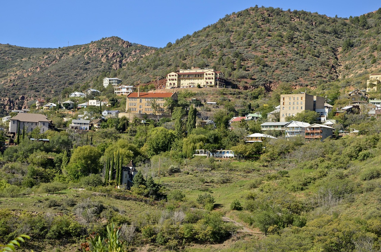
What makes the Verde Valley Loop scenic is exactly what makes it slow. The stretch of AZ-89A that climbs over Mingus Mountain between Jerome and Prescott — a series of tight switchbacks up toward 7,000 feet, with long drop-offs and views back over the whole Verde Valley — is the most beautiful driving on the circuit and the most demanding. You cannot rush it, and you should not want to. RVs and rigs towing trailers genuinely struggle on the grade; Jerome's parking is brutal on a weekend; and trying to drive the whole loop plus the town stops in one half-day means rushing every part of it — the monument, the mining town, the switchbacks, and Prescott's plaza all blurred past at speed. This is a full day, or better an overnight in Prescott — not a half-day drive. Plan it that way and the loop is one of the great circuits in Arizona; treat it as an errand and you will get the worst of both.
The Verde Valley Loop is a roughly 110-mile circuit that begins and ends in Sedona and ties together three very different Arizonas in a single day: the thousand-year-old Sinagua pueblo at Tuzigoot, the copper-mining ghost-town-turned-artist-colony of Jerome, and the cool, pine-shaded former territorial capital of Prescott. As raw driving it is only about three hours behind the wheel — but that figure is a trap, because the towns are the trip and the hardest, prettiest miles are the slowest. This guide sequences the whole circuit, in real route order, and is honest about where the time actually goes.
We run it counter-clockwise from Sedona: drop down toward the Verde Valley, stop at Tuzigoot National Monument near Clarkdale, climb the hairpins up to Jerome on Cleopatra Hill, then take the long AZ-89A grade over Mingus Mountain to Prescott's Whiskey Row and Courthouse Plaza. The return drops back down through Cottonwood — Old Town and the riverside trails of Dead Horse Ranch State Park — and climbs the last leg back into the Sedona red rocks, closing the loop where it began.
Below is the stop-by-stop, an at-a-glance schedule table, and the practical notes that matter most for this particular circuit: the Mingus Mountain grade and who should think twice about it, Jerome's weekend parking, which direction to drive, and why Prescott is the right place to split the loop into two days.
Methodology
How this loop was driven and built, and what the numbers rest on, so you can judge whether our calls match your trip:
- The route: the waypoints follow the actual Verde Valley circuit out of Sedona in real geographic order — Sedona, Tuzigoot near Clarkdale, Jerome on Cleopatra Hill, over Mingus Mountain on AZ-89A to Prescott's Courthouse Plaza and Whiskey Row, then back through Cottonwood and Old Town Cottonwood to Sedona. It is a loop: it returns to its start. This is the road locals actually drive for the circuit, sequenced to hit the demanding switchbacks mid-day and reach Prescott — the best lunch and overnight town — at the natural midpoint, not an invented detour.
- Distances, times, and elevation: the ~110-mile loop and the ~3 hours of pure driving are approximate figures given as honest round numbers, not false-precise readings. The seat-time number deliberately understates the day, because the AZ-89A Mingus Mountain grade is slow by design and the town stops are the point. Prescott sits at roughly 5,400 feet, the Mingus crest climbs toward 7,000, and Jerome and the Verde Valley floor sit lower — treat every figure as "about," and assume the towns and the grade will stretch the total well past the driving time.
- The Mingus Mountain grade is load-bearing: the AZ-89A switchbacks between Jerome and Prescott are the honest tradeoff this whole guide is organized around. The steepness and the hairpins are the scenery and the difficulty at once. We weight the advice to "give it a full day, or an overnight," and we say plainly that RVs and trailer rigs labor on this grade and that Jerome's parking compounds the problem on weekends — because pretending the loop is a quick half-day drive is the single most common way visitors get it wrong.
- How we handle the towns — first-person and respectful: Prescott's Whiskey Row is described as what it is — a genuine, continuously-operating frontier saloon block on the Courthouse Plaza, not a recreated theme. Jerome's "ghost town" reputation is treated as real history (a copper boomtown of ~15,000 that nearly emptied after the mines closed, now a living artist community of a few hundred), not a gimmick. Tuzigoot's Sinagua heritage, and the Verde Valley's connection to the affiliated Yavapai-Apache Nation, are presented as the National Park Service and the Nation present them — a place of deep, continuing significance handled factually and respectfully, never as a curiosity.
- What we name vs. what we don't: we name confirmed, durable places — Tuzigoot National Monument, the AZ-89A / AZ-260 corridor, Jerome and Cleopatra Hill, Prescott's Courthouse Plaza and Whiskey Row, Cottonwood's Old Town and Dead Horse Ranch State Park. For specific businesses, tasting rooms, and operating hours that change, we describe the category rather than vouch for a single operator. Parking and monument specifics are described at the level that stays true — Jerome's lots fill, the monuments and parks keep seasonal hours — with the advice to verify before you go.
- Refresh cycle: the seasonal parking and town guidance is re-checked each quarter; Jerome and Cottonwood parking, monument and state-park hours, and AZ-89A conditions are re-verified before each high season. Last verified: 2026-06-13.
At a Glance: The Verde Valley Loop, Stop by Stop
| Stop | Place | ~Drive from previous | Time There | Why This Stop |
|---|---|---|---|---|
| The Loop — Sedona → Jerome → Prescott → back, ~110 mi, full day | ||||
| 1 | Sedona (start, ~4,500 ft) | 0 mi — start | — | Leave early, especially on a weekend. Drop down AZ-89A toward the Verde Valley. An early start is the best move against Jerome's brutal weekend parking later. |
| 2 | Tuzigoot National Monument (Clarkdale) | ~25 mi / ~35 min | 30–45 min | A 1,000-year-old hilltop Sinagua pueblo above the Verde River. A short, mostly accessible loop and the natural first stop — the valley's deep history before Jerome's recent past. |
| 3 | Jerome (Cleopatra Hill) | ~8 mi / ~20 min | 1–2 hrs | The copper-mining ghost-town-turned-artist-colony on the hillside. Galleries, tasting rooms, overlooks. Tight hairpins up; parking is brutal on weekends, so arrive early. |
| Over the Mountain — AZ-89A, the Mingus switchbacks | ||||
| 4 | Prescott — Whiskey Row & Courthouse Plaza (~5,400 ft) | ~33 mi / ~1 hr | 2 hrs–overnight | The far end and high point, over the Mingus grade. Whiskey Row, the plaza, pine-shaded downtown — the best lunch and the natural place to split the loop into two days. |
| The Return — AZ-89A / AZ-260 down through Cottonwood | ||||
| 5 | Cottonwood — Old Town & Dead Horse Ranch SP | ~40 mi / ~1 hr | 45 min–2 hrs | Back down off Mingus to the valley floor. Old Town tasting rooms and main street, plus the riverside trails at Dead Horse Ranch — a relaxed, low-stress final stop. |
| 6 | Sedona (loop closes, ~4,500 ft) | ~20 mi / ~30 min | Rest of day | The last climb on AZ-89A back into the red rocks, closing the circuit where it began — a full sweep of Verde Valley history returned to its red rock start. |
The Loop in Detail: Around the Verde Valley
Stop 1 — Leaving Sedona
The loop starts with the same decision every Verde Valley day starts with: leave early. The circuit is short enough on paper that the temptation is to dawdle out of Sedona after a leisurely red-rock morning, but the cost of that lands in Jerome a couple of hours later, where a hillside town with almost no flat ground fills its tiny parking by mid-morning on a weekend. Drop down AZ-89A out of the red rocks toward the Verde Valley early and you buy yourself the easy version of Jerome, the cool part of the Mingus climb, and a Prescott lunch at a civilized hour.
The descent out of Sedona is its own pleasure. You leave the red formations behind and the road opens into the broad, green Verde Valley — cottonwood-lined river, vineyards, the old mining and ranching country that the rest of the day is about. Within half an hour you have traded the most-photographed scenery in Arizona for something quieter and older, and the loop's logic starts to make sense: this is a day about the layers of the valley, from a thousand-year-old pueblo to a copper boomtown to a frontier capital, stitched together by one of the state's great mountain drives.
Stop 2 — Tuzigoot National Monument
Coming down off the Sedona side, the first stop sits just outside Clarkdale: Tuzigoot National Monument, a hilltop pueblo built and lived in by the Sinagua people roughly a thousand years ago, overlooking the Verde River and its marshlands. A short, mostly accessible paved loop climbs through the masonry rooms to a view that takes in the whole valley — you can see, from one hill, much of the ground the rest of the day will cover. Thirty to forty-five minutes is enough to walk it, read the interpretive signs, and take in the setting.
Tuzigoot grounds the loop in the long human history of this valley, and it deserves to be met that way. The Sinagua heritage here, and the valley's continuing significance to the affiliated Yavapai-Apache Nation, are presented by the National Park Service and the Nation as a living connection, not a relic — and that is how we treat it. It is also the right narrative opening for the day: a thousand years of habitation here long before the copper that built Jerome, and long before the territorial politics that built Prescott. See it first and the rest of the loop reads as chapters of one place rather than three unrelated stops.
Stop 3 — Jerome on Cleopatra Hill
A short, steep run up from the valley brings you to Jerome, the loop's visual signature, clinging to the side of Cleopatra Hill in a tangle of switchbacks and stacked streets. Jerome is the famous "ghost town" of the circuit, and the label is real history rather than pure marketing: at its copper-mining peak in the early 20th century the town held something like 15,000 people, and when the mines closed in the 1950s the population collapsed to a few dozen and Jerome very nearly emptied out entirely. What you visit today is the comeback — a small, lively community of a few hundred that artists and shopkeepers brought back to life, with galleries, wine-tasting rooms, restaurants, and historic buildings perched at improbable angles above the valley.
This is where the honest tradeoff first bites. Jerome has almost no flat ground and correspondingly little parking, and on a weekend the small lots and steep street spots fill early and stay full; the hairpins up into town are tight, and an oversized vehicle has a genuinely hard time of it. The move is to arrive early, take whatever spot you find and walk, and budget real time — an hour at minimum, two if you want to wander the galleries and overlooks and have lunch. Jerome rewards being unhurried; it punishes the visitor who rolls in at noon on a Saturday expecting to park at the top.
Stop 4 — Over Mingus Mountain to Prescott
From Jerome the loop's centerpiece begins: AZ-89A climbing up and over Mingus Mountain to Prescott. This is the white-knuckle stretch — a long, steep series of switchbacks that climb toward 7,000 feet, with hairpin turns, long drop-offs, and pull-outs that look back over the whole Verde Valley and across to the red rocks you started in. It is the most beautiful driving on the circuit and, by exactly the same token, the slowest and most demanding. RVs and rigs towing trailers labor here; nervous drivers will want both hands on the wheel; and there is no version of this stretch that is quick. Take it at the grade's pace, use the pull-outs for the views rather than craning while you drive, and let it be the experience it is rather than an obstacle between two towns.
You crest the mountain and descend into Prescott, the high point of the loop in both senses — a former territorial capital at about 5,400 feet, cooler and shaded by ponderosa pine, built around the Yavapai County Courthouse Plaza. The headline is Whiskey Row, the block of 19th-century saloon buildings facing the plaza; it is a genuine piece of frontier Arizona that has been a continuously operating bar district, not a recreated theme park. Around the plaza you will find the restaurants, shops, and easy walkability that make Prescott the right place to stop for a real lunch — and, because it sits at the far end of the hardest driving, the natural place to split the loop into two days with an overnight.
Stop 5 — The return through Cottonwood
The way back is the loop's exhale. From Prescott you drop back down off Mingus Mountain — or, depending on your route, swing around via AZ-260 — into Cottonwood on the valley floor. After the morning's mountain driving this is deliberately low-stress: Old Town Cottonwood's main street is a walkable strip of tasting rooms, restaurants, and shops, and the riverside trails of Dead Horse Ranch State Park offer an easy leg-stretch along the Verde River if you have time and daylight left. It is the right note to end the active part of the day on — flat, green, and unhurried.
Cottonwood is also the loop's pressure valve. If Jerome's parking or the Mingus grade has eaten more of the day than you planned, Cottonwood is where you can trim — a quick stretch and a coffee rather than a long stop — and still make Sedona by evening light. And if you are driving a big rig and decided to skip the full Mingus loop, basing here and treating Jerome and Tuzigoot as a there-and-back is the saner plan the whole circuit points toward.
Stop 6 — Closing the loop back in Sedona
The last leg climbs AZ-89A out of the Verde Valley and back up into the Sedona red rocks, closing the circuit where it began. There is a real satisfaction to arriving back in Sedona at the end of this particular day: you have traced a thousand years of the Verde Valley in a single loop — the Sinagua at Tuzigoot, the copper boom and bust at Jerome, the frontier capital at Prescott, the river towns in between — and returned to the red rocks with the whole arc behind you.
If you have driven the loop as a full day, the timing usually lands you back in Sedona for the evening, which is the best light on the rocks anyway. If you split it with a night in Prescott, the return leg becomes a relaxed second morning rather than a tired evening push — and that, more than anything, is the case for treating this as more than a half-day drive. The loop is the same 110 miles either way; what changes is whether you experienced it or merely survived it.
Practical Notes: The Grade, Parking, and Timing
The Mingus Mountain grade — and who should think twice
The AZ-89A stretch between Jerome and Prescott is the defining piece of driving on the loop, and it is not for everyone in every vehicle. It is steep, it switchbacks tightly, and it climbs toward 7,000 feet with long drop-offs and no shortcuts. A passenger car driven by someone comfortable on mountain roads will have a wonderful time; a large RV or a vehicle towing a trailer will labor up the grade and ride the brakes coming down, and a driver who dislikes heights or hairpins will find it genuinely stressful. If that is you, the honest move is to base in Cottonwood or the Verde Valley, see Jerome and Tuzigoot as a there-and-back, and reach Prescott on a flatter route another day rather than forcing the loop.
Jerome's parking is the other bottleneck
Jerome has almost no flat ground, which means almost no easy parking. On weekends and holidays the small lots and steep street spaces fill early and stay full, and circling for a spot in a town built on a 30-degree hillside is its own small ordeal. The fix is the same as the loop's overall advice: arrive early, take the first reasonable spot you find even if it means a short uphill walk, and do not bring an oversized vehicle up the hairpins if you can avoid it. If a weekend is your only option and Jerome looks hopeless, consider reversing the loop to hit Jerome first thing in the morning before the crowd builds.
Timing — why this is a full day
The three-hour drive-time figure is the single most misleading number about this loop. The Mingus grade is slow by design, Jerome wants an hour or two, Prescott wants a real lunch, and Tuzigoot and Cottonwood each want a stop. Add it up honestly and the loop is a full day from a morning start, and it is a better trip as an overnight in Prescott. If you only have a half day, do not try to compress the whole circuit — you will rush all of it and enjoy none of it. Drive the shorter Sedona-to-Jerome out-and-back instead, and save the full loop and the Mingus switchbacks for a day you can give them.
What to pack
- Layers for the elevation swing: the loop runs from the Verde Valley floor up toward 7,000 feet on Mingus and into pine-cool Prescott at 5,400; the temperature varies a lot across one day, and the high stops run cooler than Sedona.
- Comfortable shoes: Jerome and Prescott are both walking towns on uneven, often steep ground, and Tuzigoot's loop is short but climbs.
- A vehicle you trust on grades: good brakes and tires for the Mingus switchbacks; think twice about bringing a big RV or trailer over the top.
- Sun protection and water: the valley stops are high desert and exposed; hat, sunglasses, SPF, and more water than you think year-round.
- An overnight bag, ideally: Prescott is the natural place to split the loop, and a night there turns a rushed day into a relaxed two-day circuit.
Extend Your Trip: Where the Loop Connects
The Verde Valley Loop ties together a tight cluster of northern-Arizona destinations, and the circuit is a natural launch point for more of the same region. All three are now live on The Lowdown Guide. Same-region next stops:
Jerome
The copper-mining ghost-town-turned-artist-colony on Cleopatra Hill — galleries, tasting rooms, and big Verde Valley views. The loop's visual signature, with its own full guide.
Loop start & endSedona
The red rock hub the loop circles out from and returns to — the trails, formations, the Chapel of the Holy Cross, and where to stay and eat at the start of any Verde Valley day.
Far end of the loopPrescott
The former territorial capital over Mingus Mountain — Whiskey Row, Courthouse Plaza, Sharlot Hall Museum, and a cool pine-shaded downtown. Now its own full Lowdown Guide hub.
Follow any link above to plan the next leg of the loop.