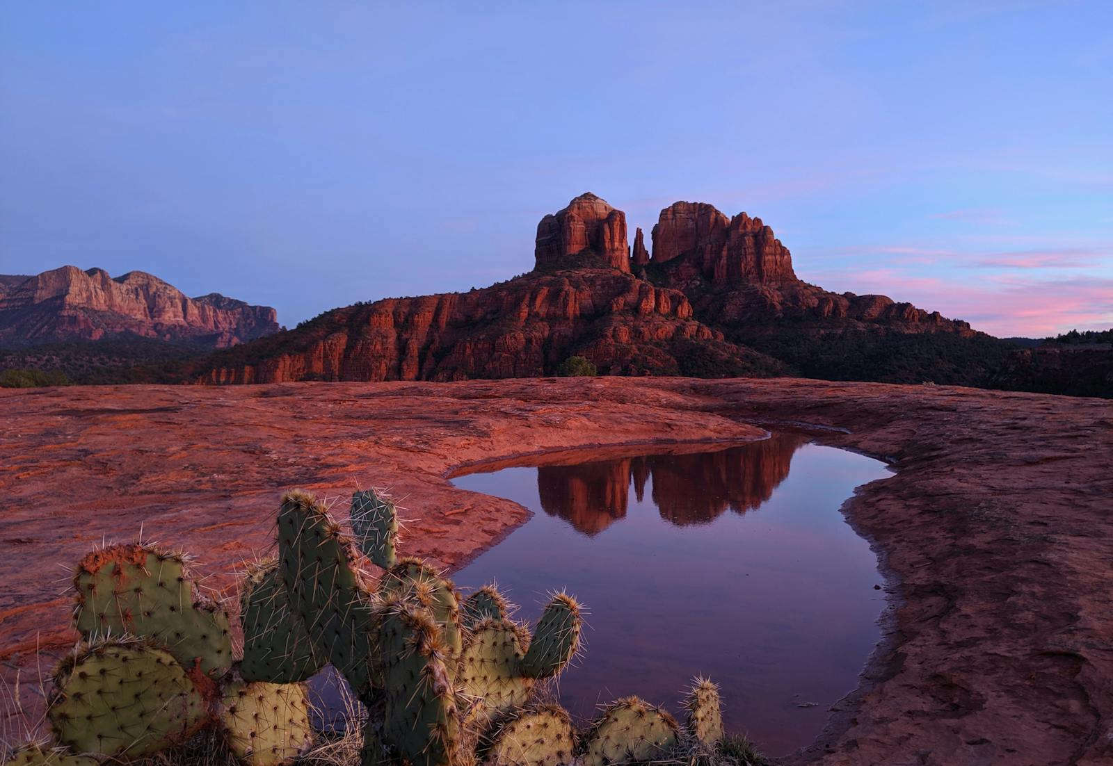
Most Sedona vortex guides pick a side. Visit-Sedona.com sells you the woo. Hard-science blogs dismiss it entirely. Indigenous-perspective sources focus on cultural context but skip the tourism-economy question altogether. This guide combines all three — the geology of these red rock formations, the cultural significance to the Yavapai-Apache and Hopi peoples whose homelands these are, and the New Age tourism economy that built itself around the energy claim — without endorsing or mocking the claim itself. That's the lens nobody else combines, and it's the reason this page exists.
The four sites covered here — Airport Mesa, Cathedral Rock (lower), Bell Rock, and Boynton Canyon — are the canonical vortex map that has been consistent since psychic Page Bryant published it in 1980. They are all on Coconino National Forest land, all freely accessible on public trails, and all genuinely worth visiting regardless of your position on the energy claim. We cover what's true about each one from each of the three lenses, and we give you the practical information you need to plan a visit: GPS coordinates, parking notes, crowd patterns, and what to bring.
One note on terminology: the original New Age usage is "vortex" with a plural of "vortexes." "Vortices" is the scientific plural. Both appear in common usage in Sedona. We use "vortex sites" and "vortexes" in the New Age context and "vortices" when the physics context makes it clearer.
Methodology
How this guide was built, what it claims, and what it explicitly excludes:
- What we sampled: All four named vortex sites — Airport Mesa, Cathedral Rock (lower vortex at Crescent Moon Picnic Site), Bell Rock, and Boynton Canyon. These are the four sites documented in Page Bryant's 1980 publication and consistently recognized as the canonical vortex map by Sedona's New Age tourism community for over 45 years.
- How we built the three lenses: Geology draws from peer-reviewed mineralogy of the Schnebly Hill Formation, USGS published documentation, and the Coconino National Forest's own geology summaries. Cultural history draws from publicly available Yavapai-Apache Nation cultural resource statements, published scholarship on Yavapai and Hopi cultural heritage in the Verde Valley, and the documented Honanki and Palatki Heritage Sites managed by the Forest Service. Tourism economy draws from documented New Age history (Page Bryant's 1980 publication; the 1987 Harmonic Convergence at Bell Rock), Town of Sedona visitor statistics, and published accounts of New Age tourism in Sedona.
- What we explicitly excluded: We do not test, verify, or endorse the energy claim. No electromagnetic or magnetic measurements were taken at any site. No claims about "feeling" a vortex are presented as evidence. This guide does not evaluate psychic or spiritual experiences — both because we have no authority to do so and because such evaluation is outside the scope of a balanced travel guide. If you have a meaningful experience at one of these sites, that experience is yours and is real regardless of whether this guide can explain it.
- Unique value declaration: The three-lens framing — geology plus indigenous cultural history plus tourism economy — is the combination that no single existing source covers in a single guide. Visit-Sedona.com covers the tourism experience. Geology sites cover the rock. Indigenous-perspective resources cover the cultural history. The tourism economy history is scattered across academic sources. We put all three in one place, with source citations, and with the explicit methodological commitment to not endorsing or mocking the energy claim. That's what makes this page citable rather than just readable.
- Refresh cycle: This page will be updated every 6 months and when Coconino National Forest changes access rules, parking fees, or trail designations at any of the four sites. Last verified: 2026-05-27.
The Geology: What Actually Formed These Rocks
The red rock formations that surround Sedona — including the four vortex sites — are composed primarily of the Schnebly Hill Formation, a sequence of Permian-age sedimentary rock deposited roughly 270 to 280 million years ago. The Permian period was a time when what is now northern Arizona was a shallow coastal plain near the equator, periodically flooded by warm, shallow seas and alternately dried out by desert winds. The resulting stratigraphy is a layer cake of red sandstone, siltstone, and mudstone, colored by iron oxide (hematite) that coats the quartz grains and gives the formation its distinctive orange-red color.
The Schnebly Hill Formation sits atop the older Supai Group (roughly 300 million years old) and is in turn overlain by the Coconino Sandstone — a paler, cross-bedded sandstone that forms the lighter-colored upper walls and caprock on formations like Bell Rock. The Coconino was deposited by ancient dune fields, and its large-scale cross-bedding (the angled layering visible on the cliff faces) preserves the record of those ancient wind patterns. Above the Coconino, in some locations, sits the Kaibab Limestone, formed from the last of the Permian sea transgressions.
The iron oxide content in the Schnebly Hill Formation is primarily hematite (Fe₂O₃), with traces of magnetite (Fe₃O₄) — a magnetic iron mineral. It is the magnetite content that has attracted some of the scientific curiosity about the vortex sites, since magnetite is the mineral responsible for the Earth's measurable magnetic field anomalies. Some vortex advocates have cited magnetite paramagnetism and quartz piezoelectricity (the property of quartz to generate small electric charges under pressure) as the physical mechanism behind the energy claim. The problem with this argument is that the Schnebly Hill Formation is not unusually rich in magnetite compared to other iron-rich sandstone formations worldwide, and no peer-reviewed study has documented anomalous magnetic or electrical field measurements at the Sedona vortex sites specifically. According to the Skeptoid Podcast's dedicated episode on the Sedona energy vortex (Episode 366), independent researchers attempting to replicate claimed anomalies have consistently found measurements within normal variance for iron-rich sandstone. The USGS has not documented or endorsed vortex energy as a measurable geophysical phenomenon.
What is unambiguously real about the geology: the 270-million-year sedimentary record, the iron oxide coloration, the differential erosion that carves the buttes and mesas, and the quartz and magnetite mineral content. Bell Rock's distinctive bell shape comes from differential erosion — harder cross-bedded sandstone in the upper Schnebly Hill Formation capping and protecting softer siltstones below, while the surrounding terrain eroded away. Cathedral Rock's spires formed along the same differential erosion pattern, with the four major spires representing the most resistant rock in the formation. Airport Mesa is a flat-topped remnant of a once-continuous plateau, its flat top preserved by the Coconino Sandstone caprock above the eroding Schnebly Hill red beds. Boynton Canyon is a slot canyon carved by water erosion over millions of years, with the canyon walls exposing the Schnebly Hill Formation in cross-section — a living geological textbook with walls you can touch.
The practical upshot for visitors: whether or not you engage with the vortex framework, you are standing on one of the most visible and accessible Permian sedimentary sequences in North America. The red color alone is worth understanding — it is the color of ancient iron, deposited when Arizona was a coastal plain near the equator, preserved in rock and visible to the naked eye 280 million years later. That is, in the most literal sense, extraordinary.
The Cultural History: Whose Homeland This Is
The Sedona red rock country is the ancestral homeland of the Yavapai-Apache Nation — a federally recognized tribe that today is centered near Camp Verde, Arizona, approximately 25 miles from Sedona. The Yavapai and Apache peoples have lived in the Verde Valley region for centuries, and their relationship to the red rock landscape is documented, continuous, and independent of any New Age framework.
The Yavapai-Apache Nation refers to many of the red rock formations by names that predate Anglo settlement by generations. According to common accounts of Yavapai oral tradition and cultural summaries available through the tribal nation, the formations were sometimes called the "Singing Sentinels" — a name that reflects the acoustic character of the canyon landscape, where wind through the rock creates a resonance that is physically real and documentable. This acoustic quality has been noted by multiple independent visitors and is likely a product of the canyon geometry, the porous sandstone, and the prevailing wind patterns. Whether this acoustic property has anything to do with the New Age energy claim is a question neither tradition has fully addressed.
The physical record of long-term indigenous presence in the Sedona red rock country is documented and accessible to visitors. The Honanki Heritage Site (approximately 25 miles southwest of Sedona) and the Palatki Heritage Site (approximately 12 miles northwest of Sedona) are cliff dwellings built by the Sinagua culture — ancestors of multiple modern Pueblo peoples, including the Hopi — dating from approximately 1100 to 1300 CE. The Sinagua occupation of the Verde Valley was contemporaneous with the broader Ancestral Puebloan expansion across the Colorado Plateau and represents a period of significant cultural exchange between peoples in the region. Both Honanki and Palatki are managed by the Coconino National Forest's Red Rock Ranger District and are accessible to visitors by reservation.
The Hopi connection to Sedona is also real and documented. The Hopi people, whose reservation is located roughly 130 miles northeast of Sedona in northeastern Arizona, trace ancestral connections to the Sinagua sites in the Verde Valley. The "Kachina Woman" spire at Boynton Canyon draws its name from a Hopi cultural figure — a kachina is a spirit being in Hopi religion, often represented in carved figures and ceremonial dances. Whether the spire was named by Hopi people, by Yavapai-Apache people, or by Anglo settlers borrowing Hopi terminology is not well-documented in the sources available for this guide, and we name that uncertainty rather than paper over it.
The critical point on cultural appropriation and the vortex framework: the Yavapai-Apache Nation has publicly stated that the New Age vortex framework is not derived from their traditions and should not be conflated with their spiritual practices. Some Sedona vortex marketing implies — and in some cases explicitly claims — a Native American origin for the vortex concept. The historical record is unambiguous: the vortex classification system dates to Page Bryant's 1980 publication and is a New Age construct, not an indigenous one. The Yavapai-Apache and Hopi relationships to these physical locations are real, documented, and deserve acknowledgment on their own terms, separate from and prior to the New Age framework that overlaid them beginning in 1980.
The Modern Tourism Economy: How New Age Sedona Got Built
Sedona's identity as a New Age spiritual destination has a specific, documentable origin. In 1980, a psychic medium named Page Bryant — who lived in Sedona at the time — published a description of four "vortex" sites in the area. According to Bryant's own account, the locations were communicated to her by a non-physical spiritual entity she called Albion. The four sites she named were Airport Mesa, Cathedral Rock, Bell Rock, and Boynton Canyon. That list, with minimal variation, has remained the canonical vortex map for over 45 years.
The vortex framework's vocabulary — upflow versus inflow, masculine versus feminine energy, balanced versus directed sites — was largely standardized in the years following Bryant's publication. The local New Age community that formed around these concepts attracted practitioners of crystal healing, channeling, meditation, and related practices. Sedona began hosting spiritual retreats, wellness centers, and metaphysical bookshops in the early 1980s. The transformation from a small art-colony and retirement town to a New Age destination was rapid.
The turning point came in 1987. The Harmonic Convergence was a global New Age spiritual event organized around a specific Mayan calendar date — August 16–17, 1987 — that its organizers (including author José Argüelles) described as a time of spiritual realignment for humanity. Bell Rock in Sedona was designated one of the primary gathering points for the event. An estimated 10,000 people converged on Sedona for the Harmonic Convergence, overwhelming the small town's infrastructure and drawing national media coverage. The event effectively put Sedona's vortex identity on the national map, and the New Age tourism economy never looked back.
The economic scale today is substantial. According to Town of Sedona visitor statistics (from common Sedona-tourism summaries — verify exact figures on the Town of Sedona's official tourism portal for current data), Sedona receives roughly 3 million visitors per year, generating several hundred million dollars in tourism revenue annually. The spiritual tourism sector — vortex tours, energy healers, crystal shops, spiritual retreat centers — represents a significant portion of that economy. Pink Jeep Tours, Sedona's largest jeep tour operator, offers vortex-focused jeep tours as a dedicated product line. Multiple tour operators offer "vortex meditation tours," "vortex energy healing tours," and guided visits that explicitly incorporate the New Age framework.
The interesting tension in the modern Sedona tourism economy is that the New Age identity both drives and occasionally limits the destination's appeal. For visitors who come specifically for the spiritual experience, Sedona's vortex identity is the reason they chose it over the Grand Canyon or another Arizona destination. For visitors who are skeptical of the energy claims but still want to see the red rock country, the heavy New Age marketing can feel like an obstacle to accessing the genuine natural and geological experience. This guide tries to serve both: you can visit all four vortex sites, understand what the framework says about them, and appreciate the real geology and cultural history, without having to buy into the energy claim — or dismiss it.
The Four Vortex Sites — A Practical Guide
Airport Mesa
GPS: 34.8474, -111.7918 | Trailhead: Airport Road, West Sedona (look for the pullouts and the Airport Loop Trail signs before you reach the airport entrance)
Airport Mesa is the most accessible of the four vortex sites and the one with the best panoramic views. The vortex spot itself — in New Age terminology, classified as balanced or "electric-magnetic" — is a low sandstone knoll roughly 0.3 miles along the Airport Loop Trail from the trailhead, marked by an unofficial cairn that the Forest Service periodically removes and visitors periodically rebuild. You don't need to identify the exact cairn to have the experience; most people simply walk out onto the open sandstone and sit.
The geological character of Airport Mesa is a flat-topped sandstone remnant — the Coconino Sandstone caprock preserved the mesa top while the surrounding terrain eroded away, leaving a natural elevated platform with 360-degree exposure. The views from Airport Mesa are genuinely exceptional: Cathedral Rock is visible to the south, Bell Rock and Courthouse Butte are to the south-southeast, Capitol Butte and the Coffee Pot formation are to the west, and the back side of the Mogollon Rim rises to the north and east. This is the only point in the Sedona basin from which all four vortex sites are simultaneously visible — something the New Age framework describes as energetically significant and geographers would describe as a good ridgeline.
Airport Mesa is also Sedona's best sunset platform, which is why the pullouts along Airport Road fill by 6 PM on most evenings during peak season. The combination of elevation, open exposure, and 360-degree sightlines makes this the correct choice for anyone who wants to see the entire red rock basin illuminated in golden-hour light. If you're visiting for the sunset, plan to arrive by 5:30 PM — the parking fills fast and does not spill over anywhere particularly convenient. The trailhead lot is small; the road-side pullouts along Airport Road are the overflow. Red Rock Pass required.
From a cultural perspective, Airport Mesa sits at the edge of the Yavapai-Apache Nation's traditional homeland boundary with the broader Colorado Plateau. The mesa would have been a logical lookout and landmark for people traveling the Verde Valley, and its visibility from multiple directions would have made it a natural orientation point for people who moved through the region seasonally. What specific cultural meaning the Yavapai-Apache attached to Airport Mesa specifically is not documented in the sources available for this guide — and it is worth noting that the absence of a published cultural designation does not mean an absence of meaning.
Cathedral Rock (Lower Vortex)
GPS: 34.8190, -111.7864 | Access: Crescent Moon Picnic Site (Red Rock Crossing), Coconino National Forest. Take AZ-179 south from Sedona, turn right on Upper Red Rock Loop Road, follow signs to Crescent Moon. $15 per vehicle day-use fee — this site does not accept the Red Rock Pass or the America the Beautiful pass.
Cathedral Rock's lower vortex — at the creek level at Crescent Moon Picnic Site — is what the New Age framework classifies as "feminine" or "inflow," said to enhance reflection, introspection, and creative energy. The upper vortex, at the saddle between Cathedral Rock's spires, requires the full Cathedral Rock Trail scramble (0.75 miles one-way, 742 feet of gain, significant hand-and-foot climbing). The lower vortex is accessible to anyone who can walk 0.1 miles on flat ground from the Crescent Moon parking lot.
The creek-level setting is specific and worth understanding. Oak Creek runs year-round here, fed by springs and snowmelt from the Mogollon Rim. The combination of flowing water, cottonwood trees, flat sandstone shelves extending into the creek, and the vertical cliff face of Cathedral Rock rising directly above creates an acoustic and visual environment that is genuinely unlike most of the other Sedona sites. You can hear the water masking the highway noise, the cottonwood leaves filtering the afternoon light, and the wind through the spires creating the resonance that gives the "Singing Sentinels" description its physical basis. Whether any of this is vortex energy or the simple physics of sound in a canyon is a question the experience doesn't resolve, and doesn't need to.
Red Rock Crossing / Crescent Moon Picnic Site is also the location of the most-photographed view in Sedona — Cathedral Rock reflected in Oak Creek, a scene that appears in virtually every piece of Sedona promotional material. The photographic best-light window is mid-morning (after the canyon walls come out of shadow) and late afternoon (when the western light hits the red sandstone directly). The picnic site has flat sandstone shelves along the creek that are used for both meditation and photography. You will see people doing both simultaneously, and that coexistence is a microcosm of Sedona's broader cultural mix.
The geological significance of Cathedral Rock's four spires: they are remnants of the most resistant cross-bedded sandstone in the Schnebly Hill Formation at this location, left standing when the surrounding material eroded. The specific geometry — four tall spires at the top of a broader base — is the result of joints (natural fractures in the rock) that ran roughly parallel to the spires' orientation. Erosion follows joints preferentially, carving out the softer material between the spires while leaving the resistant pillars standing. The same process created Devil's Bridge, the Window, and most of the other arch and spire features in Sedona's red rock landscape.
Bell Rock
GPS: 34.8033, -111.7700 | Trailhead: Bell Rock Vista Trailhead, AZ-179, Village of Oak Creek. Large parking area — one of the easiest trailheads in Sedona to access. Red Rock Pass required.
Bell Rock is classified in the New Age framework as "masculine" or "upflow" — energizing, activating, the complement to Cathedral Rock's calming inflow. This classification shapes the visitor behavior you'll observe: Bell Rock attracts more active visitors than the seated-meditation crowd at Cathedral Rock or Boynton Canyon. You're more likely to see people doing qigong, tai chi, yoga, or actively climbing the south face of the rock here than you would at the other sites.
Bell Rock the geological formation stands at approximately 4,919 feet above sea level and is one of the more structurally interesting formations in the Sedona basin. The bell shape results from the same differential erosion that formed Cathedral Rock's spires, but at Bell Rock the resistant layer is a thin band of Fort Apache Limestone — a dense, hard Permian-age limestone that forms the rounded summit knob. The Fort Apache Limestone cap protects the upper sandstone from erosion while the surrounding Schnebly Hill Formation erodes away, leaving the bell-shaped profile. Courthouse Butte, which sits to the northeast of Bell Rock and is often visited in the same circuit, was formed by the same process but has lost more of its caprock.
The 1987 Harmonic Convergence is inextricably linked to Bell Rock's cultural identity as a vortex site. According to accounts from that event, Bell Rock was expected by some participants to "lift off" — to physically rise from the earth as a spaceship or cosmic vessel in response to the spiritual gathering. Obviously, this did not happen. The story has been retold in Sedona tourism culture as equal parts earnest and self-aware; locals tend to discuss it with humor and affection. What the Harmonic Convergence undeniably did do was bring 10,000 people to Sedona, establish the town's national identity as a spiritual destination, and create an economic baseline for the New Age tourism industry that grew substantially in subsequent decades.
The Bell Rock Pathway is an easy, wide trail around the base of the formation — accessible to most visitors, with flat sandy surface and minimal elevation change at the base. The south face sandstone shelves that the New Age framework identifies as the primary vortex contact points require a moderate scramble, roughly 200 to 400 feet of elevation gain depending on how far up you go. The Forest Service asks visitors not to climb beyond the established trail network to protect the cryptobiotic soil crust on the upper sections. Sunrise and early morning light is best here — the south face of Bell Rock is illuminated from the east in the morning, making it the photographic best-light window for the formation.
Boynton Canyon
GPS: 34.9020, -111.8470 | Trailhead: Boynton Canyon Trailhead, off Boynton Pass Road in northwest Sedona. Roughly 15–20 minutes from central Sedona by car. Dirt road access — passable for most 2WD vehicles in dry conditions. Red Rock Pass required.
Boynton Canyon is the most remote of the four vortex sites and, for many visitors, the most memorable. The vortex site proper is at the Kachina Woman rock spire, reached via a 0.6-mile spur from the main Boynton Canyon Trail. The canyon extends 6.1 miles round-trip from the trailhead, but the vortex spur diverges near the canyon mouth — you can be at the Kachina Woman viewpoint in under a mile of moderate hiking, making it accessible even for visitors who don't want a full day hike.
Boynton Canyon is classified in the New Age framework as "balanced" — a combined upflow-inflow site said to integrate the energizing quality of Bell Rock with the calming quality of Cathedral Rock. The site is sometimes described as the most "powerful" of the four in vortex literature, though that designation is editorial and varies by source. What is observable: Boynton Canyon tends to attract a quieter, more contemplative visitor demographic than Bell Rock, and the physical setting — narrower canyon, taller walls, more enclosed — does create a noticeably different acoustic and spatial experience than the open-mesa sites.
The cultural importance of Boynton Canyon requires specific, careful handling. The Yavapai-Apache Nation independently recognizes Boynton Canyon as one of the most sacred locations in the Red Rock region — not because of the New Age vortex framework, but because of the canyon's significance in Yavapai-Apache cultural and origin accounts that long predate 1980. The canyon is an origin place in Yavapai-Apache cultural memory. When you visit Boynton Canyon, you are visiting a place that is sacred on two distinct and independent grounds: the New Age vortex framework and the Yavapai-Apache cultural tradition. Those two frameworks have very different histories, very different epistemological foundations, and should be understood as separate from each other even when they are physically present in the same canyon.
The Kachina Woman spire itself is a slender sandstone column visible from the Boynton Vista spur viewpoint. The Forest Service asks visitors not to touch, climb, or go off-trail near the spire — both for cryptobiotic soil protection and for cultural respect. The canyon is also where a local musician has performed Native American-style wooden flute music for many years, at the Kachina Woman viewpoint on many afternoons. This is an informal, self-organized presence — not a scheduled tour, not a paid performance. He accepts tips. The music resonates in the canyon acoustics in a way that, regardless of any metaphysical framework, is worth experiencing if you're there when he is.
Vortex Sites at a Glance: Side-by-Side Comparison
| Site | GPS Coordinates | Trail to Vortex (one-way) | Difficulty | Best Visit Time | Crowd Level | Cell Service | Parking Notes |
|---|---|---|---|---|---|---|---|
| Airport Mesa | 34.8474, -111.7918 | ~0.3 mi / ~1,600 ft | Easy | Sunset (5:30–7:30 PM) | Moderate–High (sunset hours) | Good (airport nearby) | Small trailhead lot + road-side pullouts on Airport Rd. Fills by 6 PM at sunset season. |
| Cathedral Rock (Lower) | 34.8190, -111.7864 | ~0.1 mi / ~500 ft from parking | Easy (to lower site) | Morning or afternoon (avoid midday heat) | Moderate–High (year-round) | Fair (canyon walls can interrupt) | Crescent Moon Picnic Site lot. $15/vehicle day-use. Fills by 9 AM weekends. Arrive early. |
| Bell Rock | 34.8033, -111.7700 | ~0.4 mi / ~2,100 ft (to south face shelves) | Easy–Moderate | Morning (best light on south face) | High (year-round — large parking lot handles crowds) | Good (open mesa, highway nearby) | Bell Rock Vista Trailhead — largest lot among the four sites. Rarely fills completely. |
| Boynton Canyon | 34.9020, -111.8470 | ~0.6 mi / ~3,200 ft (to Kachina Woman viewpoint) | Moderate | Mid-morning to afternoon (canyon shaded in early AM) | Moderate (more remote location filters some crowds) | Poor (canyon walls block signal — download content before arrival) | Boynton Canyon Trailhead lot — moderate size. Fills on spring/fall weekends by 9–10 AM. Dirt road — check conditions after rain. |
"Are the Vortices Real?" — The Honest Answer
This is the question every visitor to Sedona eventually asks, and most guides either dodge it or pick a side. Here is the honest answer that holds all three parts at once.
The first part: the geology is real and measurable. The Schnebly Hill Formation sandstone that makes up the four vortex sites does contain iron oxides — hematite and magnetite — and quartz, in proportions that are measurable with standard mineralogical equipment. Magnetite is a magnetic iron mineral, and quartz exhibits piezoelectricity (the property of generating a small electric charge under mechanical pressure). Some vortex advocates cite these properties as the physical mechanism behind the energy claim. The problem with this argument is specificity: the Schnebly Hill Formation is not unusually magnetite-rich compared to other iron-bearing sandstone formations worldwide, and no independent peer-reviewed study has documented anomalous electromagnetic, magnetic, or other measurable field characteristics at the four Sedona vortex sites relative to surrounding red rock terrain. According to Skeptoid's investigation and multiple independent researchers, field measurements at the vortex sites fall within normal variance for iron-bearing sandstone. The USGS has not endorsed vortex energy as a measurable geophysical phenomenon at any of these four sites.
The second part: the subjective experience is also real. Large numbers of visitors — including people with no prior New Age framework — report meaningful subjective experiences at Sedona vortex sites. This experience is real in the sense that it is genuinely felt, physiologically measurable in aggregate, and reported consistently across independent visitors. The scientific literature on meditation, intentional spiritual practice, and time in natural settings shows consistent physiological effects — reduced cortisol, lower heart rate, improved subjective well-being — across populations and settings. When visitors travel to Sedona expecting a meaningful experience, sit on 280-million-year-old sandstone for 30 minutes with eyes closed and phones away, and report a meaningful experience, that experience is occurring through a well-understood mechanism: the combined effect of intention, natural beauty, physical stillness, and the removal of everyday cognitive distraction. The vortex framework provides a narrative that gives many people permission to take that time for themselves. That is not nothing; it is, in fact, quite valuable.
The third part: the metaphysical mechanism — the claim that there is an anomalous, measurable energy field at these specific four locations that is meaningfully different from the surrounding landscape — is the part that is not supported by peer-reviewed evidence, and where this guide draws its line. We do not endorse the energy claim. We also do not mock it. The people who come to Sedona's vortex sites are, in the main, people who want to slow down, be present, and have a meaningful experience in a beautiful place. The vortex framework is one path to that. The geology is another. Knowing whose homeland this is provides a third. All three can be present simultaneously without contradiction. Sedona's ability to hold that tension — scientific, spiritual, cultural, all on the same red sandstone — is arguably its most distinctive quality.
How to Visit Respectfully
Four categories of respectful behavior apply specifically to the Sedona vortex sites, layered on top of standard Leave No Trace principles.
Leave No Trace and cryptobiotic soil: Sedona's desert soil crust — the dark, granular biological layer on undisturbed soil surfaces — is a living community of cyanobacteria, mosses, lichens, and fungi that takes decades to form and can be destroyed by a single footprint. All four vortex sites are within Coconino National Forest, where staying on established trails is not a preference but a condition of the land's ecological health. This applies specifically to the area around the Kachina Woman spire at Boynton Canyon, where the trail system has been carefully designed to keep visitors away from the most sensitive soil surfaces. Do not go off-trail.
Cairns and spiritual objects: The Coconino National Forest and Leave No Trace standards both prohibit adding to, building, or rebuilding unofficial cairns. The vortex sites — particularly Airport Mesa and Bell Rock — have a history of informal cairn-building by visitors marking the vortex spot. The Forest Service removes these cairns regularly because they mislead other hikers about the trail. Do not build or rebuild cairns. Similarly, if you bring crystals, prayer flags, ribbons, feathers, or other spiritual objects to the vortex sites, pack everything out when you leave. The National Forest prohibits leaving any items on public land, and the accumulation of spiritual objects at vortex sites has become a resource-management problem at several locations.
Respect for indigenous cultural significance: The Yavapai-Apache Nation's recognized sacred sites in the Sedona area — Boynton Canyon in particular — deserve the same respect you would give any sacred site. This means quiet, non-intrusive behavior; no photography of other visitors engaged in private spiritual practice without permission; and no conflation of the New Age vortex framework with Yavapai-Apache or Hopi spiritual tradition. The two are separate. Treat the land as if it matters — because to the people for whom this is homeland, it does.
Forest Service rules: A Red Rock Pass is required for parking at all Coconino National Forest trailheads servicing the vortex sites (Airport Mesa, Bell Rock, Boynton Canyon), and the America the Beautiful annual pass works in place of it at those three. The Crescent Moon Picnic Site at Cathedral Rock is the exception — per the Coconino National Forest, it does not accept either the Red Rock Pass or the America the Beautiful pass, and instead charges its own $15 per vehicle day-use fee (or requires a Coconino Hospitality Annual Pass). Campfires are prohibited at all four vortex site trailheads — this is a fire-risk area. Dogs are allowed on the trails but must be on leash at all times. Drones require a permit from the Forest Service and are prohibited at sensitive cultural sites including Boynton Canyon without explicit authorization.
Frequently Asked Questions
Are the Sedona vortices real?
Which Sedona vortex is the most powerful?
Can I visit all four vortex sites in one day?
Do I need a guide to visit the Sedona vortex sites?
Is there a fee to visit the Sedona vortex sites?
Are the vortex sites sacred to Native American peoples?
What is the origin of the Sedona vortex concept?
What should I know about visiting respectfully?
References
- Page Bryant vortex origin (1980): documented in Sedona Soul Adventures — "History and Legends of the Sedona Vortexes" (sedonasouladventures.com), retrieved 2026-05-21
- 1987 Harmonic Convergence at Bell Rock: World Religions and Spirituality Project — Sedona, Arizona (wrldrels.org), retrieved 2026-05-21
- Schnebly Hill Formation geology: Wikipedia — Schnebly Hill Formation (en.wikipedia.org); Benefactors of Red Rock State Park — Geology of Sedona (benefactorsrrsp.org), both retrieved 2026-05-21
- Bell Rock geology and elevation: Wikipedia — Bell Rock (Arizona) (en.wikipedia.org), retrieved 2026-05-21
- Vortex classifications (upflow/inflow/masculine/feminine): The Sanctuary at Sacred Mesa — "A Guide to the Sedona Vortexes" (thesanctuaryatsacredmesa.com), retrieved 2026-05-21
- Skeptic assessment of energy claim: Skeptoid Podcast, Episode 366 — "The Sedona Energy Vortex" (skeptoid.com), retrieved 2026-05-21
- Yavapai-Apache Nation cultural resource statements: Yavapai-Apache Nation official website (yavapai-apache.org), retrieved 2026-05-21
- Crescent Moon Picnic Site access and fees: U.S. Forest Service, Coconino National Forest (fs.usda.gov), retrieved 2026-08-19 — fee and pass-acceptance details reverified this pass; old recarea URL had gone stale and now redirects to a generic landing page
- Boynton Canyon Trail: AllTrails — Boynton Vista Trail (alltrails.com); U.S. Forest Service Coconino National Forest Red Rock Ranger District (fs.usda.gov), retrieved 2026-05-21
- Meditation and time-in-nature physiological research: NCCIH (NIH) — Meditation and Mindfulness overview (nccih.nih.gov), retrieved 2026-05-21