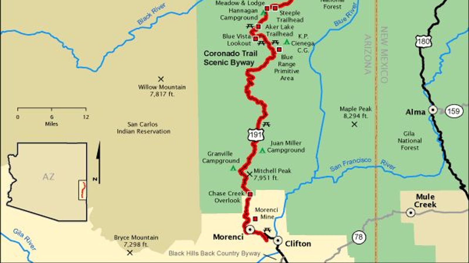
The Coronado Trail (US-191)
The Coronado Trail is the region's most famous drive, a designated scenic byway that follows US-191 through the Apache-Sitgreaves National Forests between the mining towns of Clifton and Morenci in the south and Springerville and Eagar in the White Mountains. It is known locally for an enormous number of curves packed into a relatively short distance, climbing through forested canyons and past the high-elevation stop at Hannagan Meadow before descending into the high country.
This is not a road to drive distracted or in a hurry. Services are sparse for long stretches, cell coverage is unreliable in the canyons, and the tight curves reward slow, attentive driving over speed. Fill your tank before you start, tell someone your route, and check current road conditions, since rockslides, construction, and weather can all affect the drive.
The White Mountain Scenic Road Corridor
For an easier day of driving, the paved highway corridor connecting Show Low, Pinetop-Lakeside, the Sunrise turnoff, and Eagar/Springerville is often described locally as the White Mountain scenic route. It is a far gentler drive than the Coronado Trail, running through Ponderosa pine forest with regular pullouts, lake views, and small-town stops, making it a practical option for visitors who want scenery without the demanding curves.
This corridor also works well as a spine for a longer day trip, since it connects most of the region's basecamps -- Show Low, Pinetop-Lakeside, and the Greer turnoff -- along a single route. Confirm current highway conditions before a winter trip, since sections at higher elevation can ice over even when lower-elevation roads are clear.
Fall Color Routes Around Greer and Sunrise
The stretch of highway leading toward Greer and the Sunrise turnoff generally concentrates the region's best aspen color, as the road climbs into higher-elevation forest where aspen stands mix with spruce and fir. Combining a drive out to Greer with a short detour toward Sunrise Park Resort is a common way to see a range of color in a single day trip.
Color timing shifts every year with elevation, weather, and the specific stretch of road, so treat any general fall-color window as a starting point rather than a guarantee. Check current fall color reports before planning a dedicated color trip, and build flexibility into your schedule since a good color week can shift by ten days or more from year to year.
High-Country Passes and Elevation Changes
Nearly every scenic drive in the White Mountains involves meaningful elevation change, and the Coronado Trail is the extreme case -- some stretches climb well above 9,000 feet near Hannagan Meadow before the road drops again toward the high country. That kind of elevation swing changes weather fast: a clear, warm start at lower elevation can turn into cold, wet, or snowy conditions within an hour of driving.
Pack layers and keep an eye on temperature and cloud cover as you climb, especially in shoulder-season months when snow is possible at the higher elevations even while it is warm in Show Low or Pinetop-Lakeside. Altitude can also affect how a vehicle handles and how tired a driver gets, so plan rest stops on the longer high-elevation routes.
Seasonal Road Closures and Winter Driving
Winter changes the calculus for every drive on this list. Snow and ice can close or seriously slow high-elevation sections of the Coronado Trail and the routes toward Sunrise and Greer, and closures do not follow a fixed calendar -- they depend on that year's storm pattern. A road that is fine one week can be hazardous or closed the next.
Check AZ511 or the Apache-Sitgreaves National Forests office for current road status before any winter or shoulder-season drive, and carry tire chains or traction devices if there is any chance of snow. If conditions look questionable, the lower-elevation SR-260 corridor is generally a safer fallback than the Coronado Trail.
Summer Monsoon and Lightning (June 15 – September 30)
Arizona's official monsoon season runs June 15 through September 30. On these drives, especially the high-elevation Coronado Trail and the routes toward Greer and Sunrise, thunderstorms can build rapidly in early afternoon. If you hear thunder, get off the road or into your vehicle and shelter in place until 30 minutes after the last thunder -- do not stand at an open overlook or exposed ridgeline waiting out a storm. The National Weather Service states there is no safe place to be outside in an active thunderstorm. Plan scenic stops and short walks for morning hours during monsoon season, and monitor the sky as you drive. (NWS Phoenix: weather.gov)
Planning a Scenic-Drive Day
Fuel up before you start any of these routes, since gas stations thin out fast once you leave Show Low, Pinetop-Lakeside, or Springerville/Eagar. Download offline maps if you plan to drive the Coronado Trail, because cell service is unreliable through much of the canyon country, and let someone know your planned route and return time.
Give yourself more time than the mileage alone suggests -- curves, overlooks, and small-town stops all add up -- and check current road and weather conditions the morning you leave rather than relying on conditions from a prior trip. A flexible plan beats a fixed one on roads this dependent on elevation and season.