What Glen Canyon Dam Is and Why It Matters
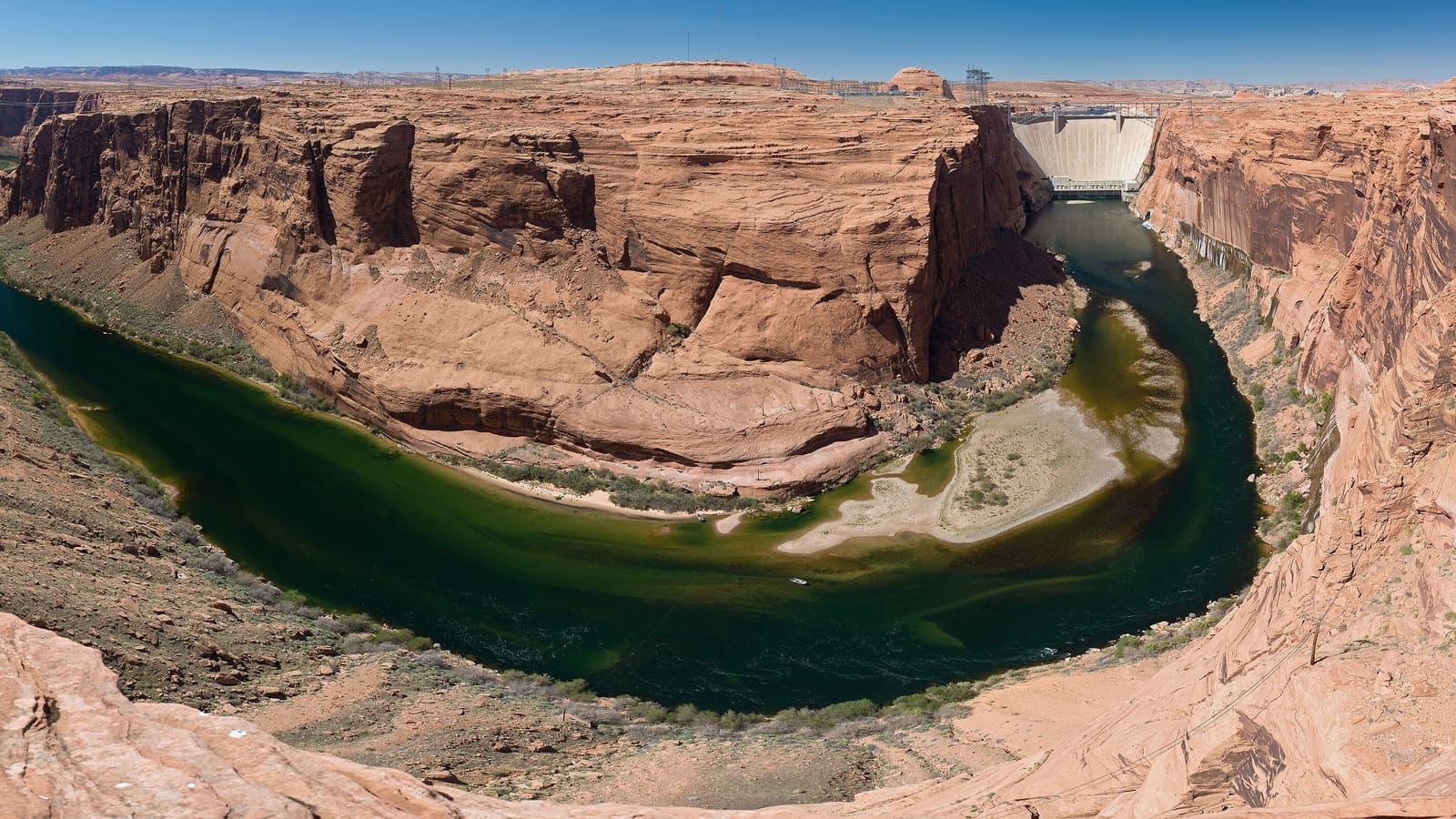
Glen Canyon Dam sits on the Colorado River at the downstream end of what was once one of the most spectacular canyon landscapes in North America. Completed in the 1960s, the dam backs up Lake Powell and provides hydroelectric power for a large portion of the Southwest. It is operated by the Bureau of Reclamation and is administered jointly with Glen Canyon National Recreation Area.
The dam's construction was among the most contested infrastructure projects of the twentieth century. The Sierra Club's famous campaign against it in the 1950s and 1960s failed to stop the dam but galvanized the American environmental movement. Today, ongoing debates about the dam center on water allocation in the drought-stressed Colorado River basin, declining reservoir levels, and the future of hydropower in the region.
Whether you visit primarily as a traveler interested in engineering, in the water politics of the American West, or simply because it is on the way to Wahweap Marina, the dam rewards attention. The scale is genuinely impressive, and the visitor center presents a frank account of both the dam's achievements and the landscapes it submerged.
The Carl Hayden Visitor Center
The Carl Hayden Visitor Center sits directly adjacent to the dam on the Arizona side. Exhibits cover the dam's engineering, the history of the Colorado River Compact and water law in the West, the geology of the canyon country, and the plants and wildlife of the region. The center has a viewing platform overlooking both the dam structure and the canyon below.
The visitor center is the starting point for guided dam tours when they are available. It also serves as an orientation resource for anyone planning to spend time in Glen Canyon National Recreation Area. Staff can provide current information on lake levels, marina access, and conditions affecting specific activities on the reservoir.
Visitor center hours vary seasonally -- the facility has historically been closed or operated on reduced hours outside peak season. Verify current hours with the NPS before planning your visit, particularly if you are arriving outside the summer months or plan to arrive early or late in the day.
Guided Dam Tours
Guided tours of Glen Canyon Dam have taken visitors inside the structure to see the generator floor, the penstock tunnels, and the mechanical systems that convert water flow into electricity. This is the part of the dam that most visitors never see from the overlook, and the scale of the turbine hall -- the noise, the size of the equipment, the sense of industrial power -- is striking in person.
Tour availability, frequency, and any security screening or identification requirements change over time and can be affected by operational needs at the dam. Guided access to active infrastructure like a hydroelectric facility is managed more carefully than a typical national park attraction. Contact the Carl Hayden Visitor Center directly or check nps.gov/glca before your visit to confirm current tour schedules and what you need to bring for admission.
If guided tours are not available during your visit, the exterior overlook and visitor center exhibits still offer substantial context. The view from the bridge across the canyon is significant in its own right -- looking downstream into the narrow canyon that the Colorado River cut over millions of years gives a sense of the geological history that the exhibits describe.
The Glen Canyon Dam Bridge and Overlook
US-89 crosses the Colorado River on a bridge immediately adjacent to the dam. Pedestrians can walk across this bridge for a view of the dam face on one side and the canyon below on the other. The downstream view shows the river emerging from the base of the dam, turquoise-green against the orange canyon walls -- a color that surprises first-time visitors who expect the Colorado to run muddy brown.
The water below the dam runs cold and clear year-round because it releases from a depth below the thermocline of Lake Powell. This cold tailwater supports a productive trout fishery that extends downstream into Lees Ferry. If you are combining a Glen Canyon Dam stop with a Lees Ferry visit, the contrast between the developed Page corridor and the remote canyon at Lees Ferry is worth experiencing.
Parking at the visitor center and bridge area has limited capacity during peak season. The lot fills on summer mornings when combined visitor traffic from the dam, Antelope Canyon tours, and Horseshoe Bend all converge on the Page corridor. Arriving before mid-morning or after mid-afternoon helps avoid the busiest parking windows.
Lake Powell Water Levels and What They Mean
The single most important variable affecting a Lake Powell trip today is the water level. The reservoir has experienced dramatic declines over the past two decades, exposing canyon walls, stranding boat ramps, and reducing access to side canyons that were previously navigable. The high-water marks visible on the canyon walls near the dam tell the story clearly.
The Bureau of Reclamation publishes current reservoir elevation data at usbr.gov. Check this before finalizing any boat-based plans, and contact the marinas directly to confirm which ramps are operational. Low water has at times reduced or eliminated access to Antelope Point and other facilities that visitors assume will be open.
The visitor center staff can provide the most current practical information on how water levels are affecting activities on the lake. This is one of the better reasons to stop at the visitor center even if the dam itself is not your primary interest -- getting a current read on conditions from people who are there every day is more reliable than any pre-trip online research.
Combining the Dam with Other Page-Area Stops
The dam visitor center is a natural first stop in Page because it provides orientation for everything else in the area. After the visitor center and bridge overlook, the short drive to Wahweap Marina and then to Horseshoe Bend can fill a productive half-day. Antelope Canyon tours require separate advance booking and run on their own schedule, but they are all within a few miles of the dam.
Lees Ferry, a historic Colorado River crossing and the launch point for Grand Canyon river trips, is a drive south of Page. It sits below the dam and offers a very different character -- remote, quiet, and accessible only by a long road through open desert. Check current access conditions and confirm it fits your travel timeline before adding it to your itinerary.
For visitors spending more than one day in Page, building a morning around the dam and visitor center on arrival day leaves the afternoon and following days free for activities that benefit from early starts -- like Antelope Canyon tours (which book specific entry times) and full-day boat excursions to Rainbow Bridge.