Location and Getting There
Horseshoe Bend is located approximately 5 miles south of the Carl Hayden Visitor Center in Page on US-89, at highway mile markers 545 to 544. The turnoff is well-signed on the right (west) side of the highway when driving south from Page. The parking lot is large and managed by the City of Page. Jurisdiction here is layered: Horseshoe Bend itself and that stretch of the Colorado River are part of Glen Canyon National Recreation Area, the trail and overlook sit on Navajo Nation land, and the parking area is City of Page land. Because the lot is city-run, America the Beautiful and National Park Service passes do not cover the parking fee -- a separate charge applies. Verify the current fee at the parking kiosk or on the City of Page website before your trip, as fees have changed over time.
There is no regular shuttle service from Page to Horseshoe Bend, so plan on your own vehicle. On holidays and busy weekends the City of Page may require all visitors to use a shuttle once the parking lot fills, so check with the City before a peak-season visit. The drive from Page takes roughly 10 minutes on US-89, and the road is paved and well-maintained. GPS coordinates for the parking lot are reliable from any mapping application. Do not park on the highway shoulder -- vehicles parked along US-89 are ticketed and towed, and the City of Page also prohibits passenger drop-offs and pickups at the Horseshoe Bend entrance and along the Highway 89 corridor.
Accessibility at Horseshoe Bend has improved in recent years. The 1.5-mile round-trip path is a hardened, sand-based surface built to be accessible under the regulations of the Architectural Barriers Act, and the City of Page describes it as welcoming wheelchairs, strollers, and leashed dogs. Handicap-accessible parking is located near the trailhead. Check the City of Page or NPS website for the most current accessibility information before planning a visit around specific mobility needs.
The Hike to the Overlook
The trail from the parking lot to the canyon rim is approximately 1.5 miles round trip. The elevation change is modest. The surface is a hardened sand-based mixture rather than pavement, and it takes more effort than a flat sidewalk. The National Park Service recommends sturdy footwear, plenty of water, and sunscreen -- sandals are a poor choice here, and in summer the parking lot and trail get too hot for bare feet and bare paws.
There is little to no shade on the trail, and the National Park Service advises avoiding the hike during the hottest part of the day. From late spring through early fall, the exposed approach in full sun is the primary physical challenge. The National Weather Service notes that during extreme heat waves the Page and Lake Powell region can easily exceed 105 to 115 degrees Fahrenheit in the late afternoon. Water is not available anywhere along the trail. Bring more than you think you need -- the combination of sun, dry air, and moderate exertion depletes hydration faster than most people expect at home-elevation.
The trail is one-way in the sense that you return on the same path you walked in. There is no loop option. The overlook is a fixed endpoint at the canyon rim. There are railings at the edge of the viewing platform, but not along the trail, and beyond the viewing deck the edge is rocky with no railings at all. The canyon here is roughly 1,000 feet deep, and much of the rim remains exposed to that drop -- watch your footing and keep track of children and pets. The scale of the bend only becomes apparent as you approach the edge; it is considerably deeper than it appears in photographs taken from a distance.
Best Time of Day to Visit
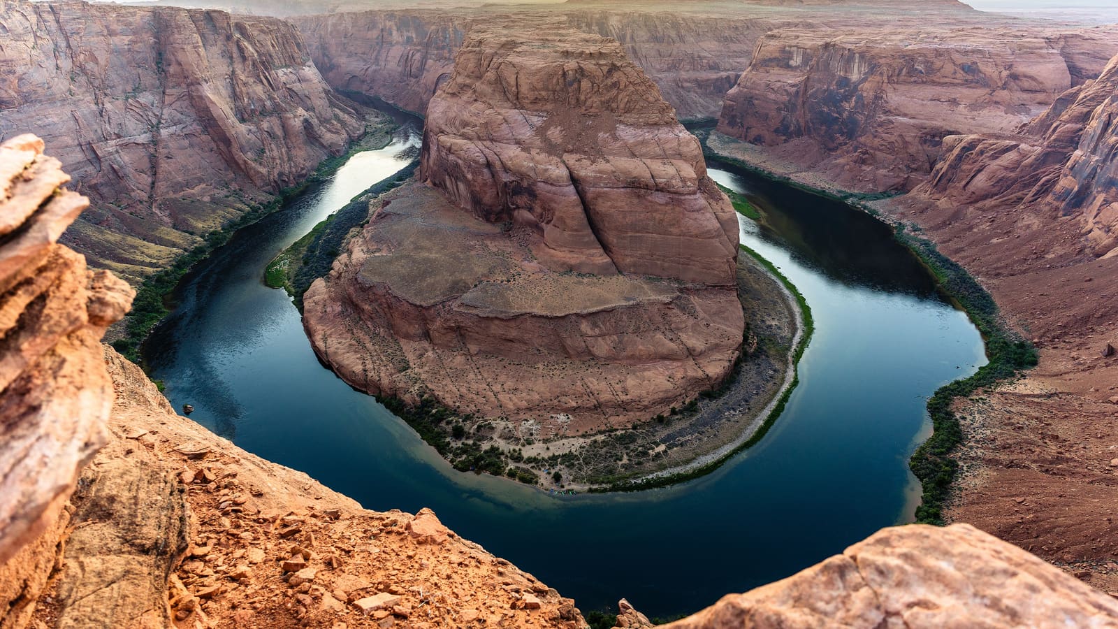
The Colorado River loops through a full 270-degree horseshoe below the overlook, so the light angle on the canyon walls changes dramatically throughout the day and no single wall stays lit for long. Early morning light reaches the canyon at a low angle and the water holds morning color well. Late afternoon brings warm golden light. Midday produces flat overhead light with harsh shadows in the canyon bottom -- functional for a visit but not the ideal photography window.
In summer (June through August), midday temperatures at the overlook are serious. Going before 8 AM or after 5 PM reduces heat exposure significantly and tends to reduce crowd density. Sunrise visits in summer involve very early starts from Page -- the sun rises early here in summer, so check the sunrise time for your specific date and plan to be on the trail well before it. Bring a headlamp if you plan to arrive before dawn.
Fall (September and October) is the most comfortable season for a midday visit. Temperatures are moderate, crowds are lower than summer, and the light in the shoulder hours of morning and afternoon is excellent. Spring (March through May) brings pleasant temperatures but increasing crowds as spring break season runs into peak tourist traffic by April and May.
Photography at Horseshoe Bend
The classic wide-angle shot looks straight down into the bend from the center of the overlook railing. A wide or ultra-wide lens (equivalent to 16-24mm on a full-frame camera) captures the full arc in a single frame. Longer focal lengths isolate sections of the canyon wall and the river. Both approaches produce compelling images -- the wide-angle shot is more iconic, but selective compositions with longer lenses often feel more personal.
A polarizing filter reduces glare from the river surface and deepens the blue of the water. A neutral density filter allows longer exposures in bright conditions to smooth the water and deepen the canyon colors. Neither is necessary for a solid image, but both are useful tools if you carry them. Tripod use is possible at the overlook, though crowds during peak hours create challenges for extended setups.
The canyon below is deep enough that lens flare from direct sun is a factor in midday shots. Shooting with the sun behind you minimizes flare. In early morning and late afternoon, the sun angle is lower and the light is warmer -- this is when most photographers prefer to work. Cell phone cameras perform well here; the scale and color of the canyon are strong enough subjects that technical equipment matters less than timing.
What You Cannot Do at Horseshoe Bend
There is no path from the overlook down to the Colorado River. The canyon wall below the rim is a sheer sandstone drop with no trail, no stairs, and no access. Swimming in the river at this location is not possible from the Horseshoe Bend overlook trail -- river access requires a river trip or launch from a separate point entirely. Do not attempt to descend the canyon walls from the overlook.
Drones are not allowed. The National Park Service prohibits launching, landing, or operating an uncrewed aircraft from or on lands and waters it administers within Glen Canyon National Recreation Area, and the City of Page bans drones -- along with bikes, skateboards, and motorized vehicles -- on the Horseshoe Bend trail. Do not plan on aerial footage here.
Pets on leash are permitted on the trail. In summer the parking lot and trail are too hot for bare paws, so plan accordingly or leave the dog behind. Beyond the viewing deck the rim is rocky and has no railings, and much of it is exposed to the roughly 1,000-foot drop. Keep children and pets close and stay on the designated viewing areas.
Practical Details Before You Go
Horseshoe Bend is open year-round, though hours for the parking area may vary seasonally. Verify current hours and fees on the City of Page website or at the kiosk before assuming free or unlimited access. The parking lot can fill completely during peak summer mornings -- arriving before 7 AM or after 4 PM reduces the chance of a full lot.
The National Park Service is explicit that there are no toilets along the trail and no water available along the trail. Confirm restroom availability at the trailhead parking area with the City of Page rather than assuming it. Bring everything you need before you leave your vehicle, and do not count on food or water being sold at the site.
The total time commitment from parking lot to overlook and back is typically 45 to 60 minutes at a comfortable pace. Photographers and visitors who spend more time at the rim can stretch this to 90 minutes or more. Factor travel time from downtown Page (approximately 10 minutes on US-89) into your schedule. If you are combining Horseshoe Bend with an Antelope Canyon tour on the same day, morning at Horseshoe Bend followed by an afternoon Antelope Canyon slot is a practical sequence.
Want to see it from the water instead? Guided kayak and raft trips on the Colorado River below Glen Canyon Dam pass beneath the bend, and scenic flights out of Page's airfield pass over it -- see our Horseshoe Bend from the Water guide for both options.