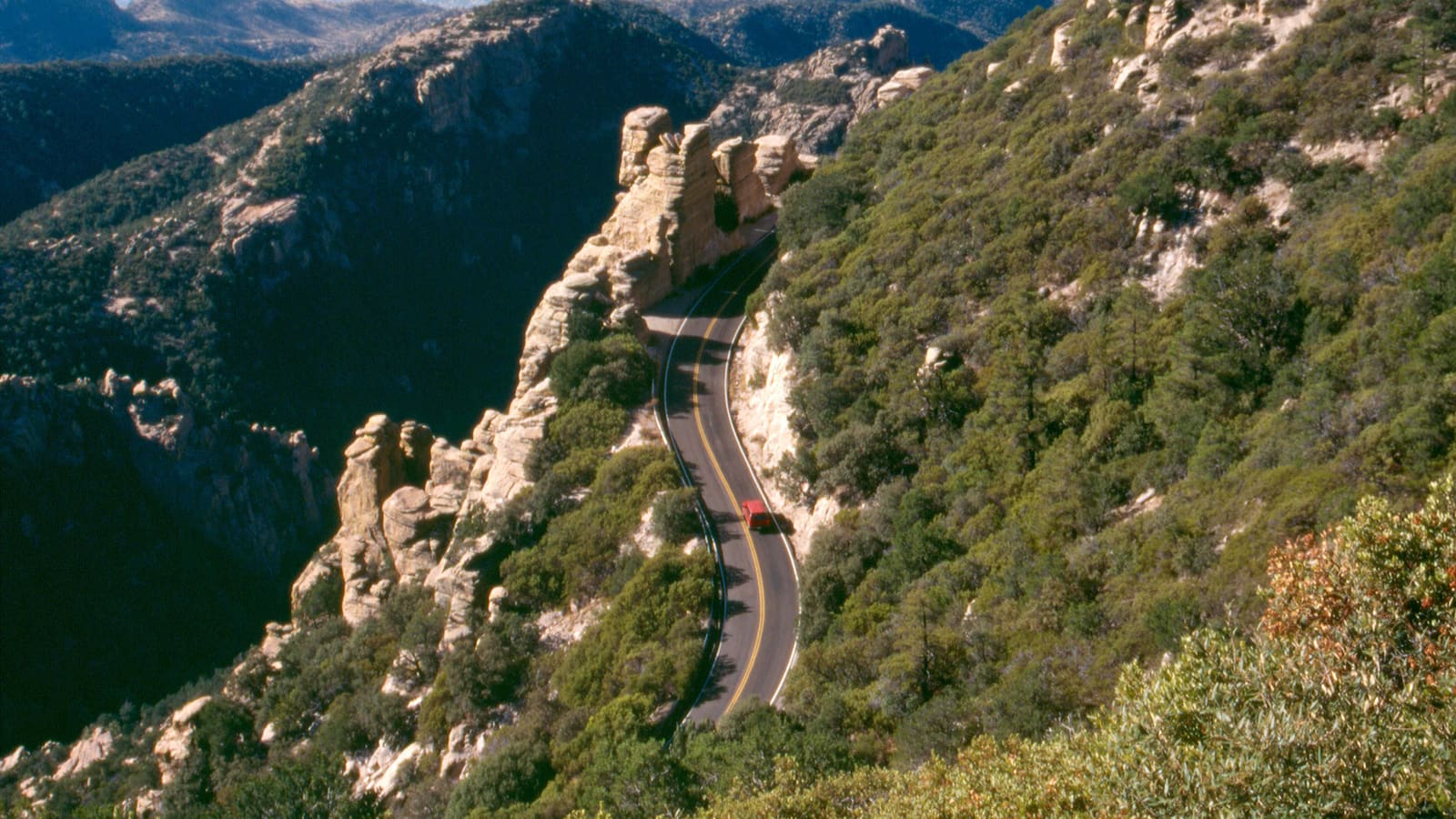
What the Sky Island Scenic Byway Actually Is
The Santa Catalina Mountains, which rise directly north of Tucson, are one of the region's "sky islands" -- isolated mountain ranges that climb high enough above the surrounding desert to support forest ecosystems that would otherwise be found much farther north. Mount Lemmon, at 9,157 feet, is the highest point in the range, and the Forest Service describes the road that climbs nearly to its summit as the only paved route into the upper reaches of the Santa Catalinas. The Federal Highway Administration lists the route in its America's Byways program as the Sky Island Scenic Byway, 27.2 miles long and managed by the Coronado National Forest; the Forest Service itself calls it the Catalina Highway Scenic Drive or Mt. Lemmon Highway, and it was originally built as the General Hitchcock Highway between 1933 and 1950. Most locals just say "the Catalina Highway."
What makes the drive notable is the sheer compression of ecological zones into a short distance. The Forest Service puts it this way: the road starts in the Lower Sonoran vegetative life zone and climbs to the high forests of the Canadian zone, offering "the biological equivalent of driving from the deserts of Mexico to the forests of Canada" in a stretch of 27 miles. That is an ecological comparison, not a literal one -- you are climbing about 6,000 vertical feet, from roughly 3,000 feet at the base to conifer forest near 9,100 feet, and the vegetation changes accordingly. This is the core reason the drive is worth doing on its own merits, independent of any single destination at the top.
The Catalina Highway: Route and Character
The Catalina Highway begins on the northeast side of Tucson and runs 27 miles, climbing from about 3,000 feet in the desert to mixed conifer forest near 9,100 feet -- roughly 6,000 feet of elevation gain, per the Coronado National Forest. The road is fully paved and generally well maintained, but it is a genuine mountain road -- narrow in places, with sustained curves and grades that keep average speeds well below what the posted limits might suggest on a straighter road. This is not a highway to rush; plan on the drive itself taking meaningfully longer than the mileage alone would imply.
Numerous pullouts and viewpoints line the route, and several are worth stopping at even on a first drive -- the views back down over the Tucson basin open up dramatically as elevation increases, and the transition through vegetation zones is easiest to appreciate when you actually get out of the car periodically rather than driving straight through. Picnic areas and trailheads are scattered along the corridor as well, run by the Coronado National Forest, which manages most of the land the highway passes through above the city limits.
Cyclists also use the Catalina Highway, and it has a reputation among road cyclists as a serious climb -- share the road and expect to encounter riders, particularly on weekend mornings. Cell phone service can be inconsistent along parts of the route, so it is worth downloading offline maps or noting directions before setting out if you are relying on a phone for navigation.
Summerhaven and the Upper Mountain
Summerhaven is the small community near the top of the byway, sitting in pine forest at an elevation that puts it in an entirely different climate zone from Tucson below. It is a small mountain settlement rather than a full-service town -- a cluster of cabins, a handful of small shops, and a few places to eat, most oriented toward the day-trip and weekend-cabin crowd rather than long-term residents. It is the practical endpoint for most people driving the byway, and it makes a reasonable place to stop, walk around, and get a sense of the pine-forest environment before heading back down.
Mt. Lemmon Ski Valley, the small ski area near Summerhaven operating under permit within the Coronado National Forest, describes itself as the southernmost ski destination in the continental United States, with a top elevation of 9,157 feet, 21 runs across about 200 skiable acres, two chairlifts and one surface tow. It is open year-round rather than only in winter: the chairlift runs all year as the scenic SkyRide, while the ski runs themselves are usually open from mid-December to early April and depend entirely on natural snowfall, since the area does not make its own snow. The operator also notes ticket sales can close early in rain, wind or lightning, and caps the SkyRide at two people per chair regardless of age or size. Confirm current days and hours directly with Ski Valley before planning a visit around a lift ride. The upper mountain area also has hiking trails accessible from the highway corridor, ranging from short interpretive walks to longer routes into the surrounding Coronado National Forest backcountry.
Snow Up Top, Desert Below
One of the more striking features of the Mount Lemmon area is the seasonal contrast between the summit and the desert floor. In winter, the upper elevations near Summerhaven regularly receive snow, while the city of Tucson below almost never does. It is genuinely possible to leave a mild, sunny Tucson morning and reach snow-covered ground within about an hour of driving -- a novelty that draws a steady stream of visitors, particularly desert residents who rarely see snow otherwise. Road conditions after a storm can require extra caution or temporary closures. The Coronado National Forest points drivers to the Pima County Sheriff's road-condition hotline at (520) 351-3351 for current Catalina Highway conditions -- use that rather than a statewide map, since this is not a state highway. Note also that the Forest Service keeps the access road beyond Mt. Lemmon Ski Valley closed in winter, so the very top of the mountain is not always drivable.
In summer, the relationship flips into the drive's other major appeal: escaping desert heat. Tucson summers regularly bring extended stretches of triple-digit heat, and the elevation gain up the Catalina Highway produces a substantial temperature drop -- often 20 to 30 degrees Fahrenheit cooler near the top than at the base, sometimes more. This makes the drive a genuine heat-relief strategy for Tucson residents during the hottest months, not just a scenic outing, and it is one of the reasons the byway sees heavy weekend traffic from roughly May through September.
Timing the Drive
Weekends, particularly summer weekend mornings, bring the heaviest traffic on the Catalina Highway as Tucson residents head up to escape the heat -- expect slower going and fuller pullouts and picnic areas during these windows. A weekday drive, or an early start on a weekend, generally means a quieter road and easier access to the more popular overlooks and trailheads. Weather can also shift quickly at elevation, so checking a mountain-specific forecast rather than the Tucson forecast alone is worth doing before you leave, especially outside the warmer months.
Fall and spring both offer a middle ground -- cooler than a Tucson summer, generally free of the winter snow-and-ice concerns, and with lighter crowds than peak summer weekends. Whatever the season, allow more time than the raw mileage suggests: between the curves, the pullouts worth stopping at, and any time spent in Summerhaven, a round trip that covers the full byway with a reasonable number of stops is realistically a half-day commitment.
Practical Notes
A recreation fee is required to stop at the fee sites along the corridor -- the picnic areas, trailheads and the Palisades Visitor Center. As posted by the Coronado National Forest, day use runs $8 per vehicle per day or $10 per vehicle per week, and a $40 Coronado National Forest annual pass covers the forest's sites; the federal Interagency (America the Beautiful) pass is also accepted, and proof of payment must be displayed. There is no per-person fee for walking or bicycling into a site. Fees change, so confirm current amounts and payment locations with the Coronado National Forest before your trip. Fuel up before starting the climb -- gas stations are not reliably available along the byway itself. Bring layers regardless of season; the temperature difference between the base and the summit is large enough that what feels comfortable in Tucson can be genuinely cold or genuinely warm at the top, depending on the time of year.
The road is generally suitable for standard passenger vehicles in good weather, but winter storms can change that quickly -- carrying chains or checking current requirements is worth doing for a cold-season trip. Because the drive itself is the main event, resist the urge to treat it as a straight shot to Summerhaven; the pullouts and short trail access points along the way are where much of the value of the byway actually lives.
Safety on the Mountain
Summer thunderstorms are the biggest hazard, and they hit the mountain before they hit the city. The National Weather Service in Tucson defines the monsoon as June 15 through September 30 and calls it the most dangerous time of year weather-wise in the Southwest. Thunderstorms typically form in early to mid-afternoon and develop first over higher terrain -- which is exactly where you are on Mount Lemmon. The NWS advice is direct: plan activities to avoid being outside between mid-afternoon and evening, especially at higher elevations, and remember that if you can hear thunder you are close enough to be struck. "When thunder roars, go indoors" -- a substantial building or a fully enclosed metal vehicle, not a ramada or a tree -- and wait 30 minutes after the last thunder before going back out. On a summit at 9,000-plus feet, an exposed overlook or ridge trail is the wrong place to be when a cell builds. Start early and be heading down by early afternoon in monsoon season.
Never drive into water running across the road. Monsoon rain sheets off the mountain into washes and low crossings on both the highway and the roads back into town. The NWS notes that as little as ten inches of water can float an average car, minivan, SUV or truck, and that water depth is very easy to misjudge -- the roadway underneath may already be gone. Turn around, don't drown; never drive around barricades; and if in doubt, wait it out or take another route. Dust storms are a separate driving risk on the flats around Tucson: if you cannot avoid one, ADOT and the NWS say pull as far off the road as you safely can, turn off all your lights including brake lights, set the parking brake and wait it out, so no one follows your taillights off the pavement.
In winter, treat it as a mountain drive, not a city errand. ADOT's cold-weather guidance is to check conditions before leaving, keep at least a three-quarter-full tank, tell someone your route and expected arrival time, slow down and allow extra travel time, brake gently rather than panic-braking, and increase your following distance. Ice forms on bridges first and is hard to see. ADOT's suggested cold-weather kit is blankets, extra clothes, a flashlight, an ice scraper, a shovel, sand for traction, a fully charged phone, warning reflectors, plus food, water and any medications -- along with chains, snow cables or snow tires if conditions call for them. For this specific road, check the Pima County Sheriff's road-condition hotline at (520) 351-3351 before you start up.
Dress for two climates and don't count on your phone. With roughly 6,000 feet of elevation gain, the top can be 20 to 30 degrees Fahrenheit cooler than the trailhead, and it is often windy -- bring a layer even on a hot day, and more than one from late fall through mid-spring. Cell coverage is inconsistent along parts of the corridor, so download your map and note the route before you leave Tucson rather than relying on live navigation. There are no reliable fuel stops on the byway, so fill up in the city, and carry water regardless of season.